Geography

The World: Map of N. & S. America
Matthaeus Seutter was an acclaimed German mapmaker in the early eighteenth century. He published maps that introduced the geography of the Americas to many people who would never set foot on the continents themselves.
Witches
Witches is well-conceived and equally well-presented project that takes our understanding of Scottish witchcraft one step further
Pueblo of Texupa
This is a copy of a relación geográfica.

America Invertida (Inverted America)
We generally expect maps to convey the location of oceans and land masses accurately. But why do almost all maps and globes position North at the top and South at the bottom, when there is no up or down orientation of the universe?

Digital Library of the Caribbean
Educators, students, and scholars interested in understanding the strategic conflicts between European powers, the experience of Africans during the transatlantic slave trade, the emergence of the modern capitalist system, and the rise of neoliberalism would find in dLOC a wealth of content to draw
Primer: Oceans
Oceans, which cover approximately 70 percent of the earth’s surface, have played a crucial role in shaping human history. Using oceans and seas as a unit for analysis is, however, a relatively new framework for historical analysis.
Short Teaching Module: European Maps of the Early Modern World
I use images of three historical maps for topics on colonial exploration and for interpreting historical evidence in undergraduate courses on history and historical methodology. I have several aims in using the maps.

From John Bartholomew, Literary and historical atlas of America
This unusual map appeared in a 1911 atlas of America by John George Bartholomew, a prestigious Scottish cartographer and geographer. In this map Bartholomew dramatized the provincialism of European cartography three centuries earlier.
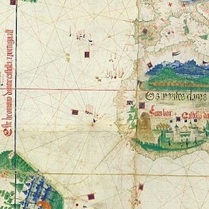
Cantino planisphere
The famous Cantino planisphere was made in 1502 by an anonymous Portuguese official at the request of Alberto Cantino, an Italian agent in Lisbon of Ercole d’Este, Duke of Ferrara.

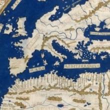
World map by Henricus Martellus
Henricus Martellus was a German geographer and cartographer who worked in the Italian city of Florence from 1480 to 1496. His book of 1490, Insularium Illustratum ("Illustrated Book of Islands"), in which this map appeared, was widely circulated for two reasons.