Browse
Geography

Review
Canadiana
With a catalogue containing sixty million pages of material spanning the seventeenth to twentieth centuries, scholars and educators will have no shortage of material to consult on every aspect of Canada’s past.
Review
BBC Ancient Egypt
Created with the help of academics, writers, and broadcasters, the BBC’s Egyptians webpage provides an excellent, easily digestible overview of Ancient Egypt through a series of essays and photo galleries.
Review
Primary Source: Educating Global Citizens
Such sources are indeed a superb addition to one’s class; unquestionably the materials on the Primary Source site can help enhance any class.
Source
Hernán Cortés: Second Letter to Emperor Charles V, 1520
This text is an excerpt of a letter sent from Spanish conquistador Hernán Cortés to the Spanish King, Charles V, in 1520.

Review
Juxtapose: Easy-to-make frame comparisons
This tool is perfect for historians because it emphasizes visual representations of change over time.
Review
MapWarper
This can be a powerful tool to understand the spatial orientation of past places or events and to present spatial history projects directly onto contemporary maps.
Review
Livingstone Online
While the site is primarily dedicated to digitising the famed British explorer’s works, Livingstone Online is far more than a mere repository of primary sources.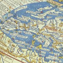
Methods
Analyzing Maps
The map is one of the oldest forms of nonverbal communication. Humans were probably drawing maps before they were writing texts. Mapmaking may even predate formal language. As far as historians and geographers can determine, every culture in every part of the world uses and makes maps.

Review
A History of the World in 100 Objects
Overall A History of the World in 100 Objects is a great resource to teach world history through visual culture in an accessible and succinct format for both school and college-level classes.
Source
Map of the Partition of Israel and Palestine
In 1947, Britain announced that it would terminate its mandate government in Palestine. As a result, a special committee formed by the United Nations was charged with partitioning the territory into separate, sovereign states.