Geography

Romania and Its Neighbors
Modern map of Romania. Timişoara (Temesvar in Hungarian) has become more homogeneous during the 20th century, but remained a multi-lingual, multi-ethnic, multi-confessional city, closer in distance and perhaps culture to the Serbian (Yugoslav) and Hungarian capitals than to Bucharest.

Romania and Its Neighbors
One of the more challenging parts of teaching Romania is the relative unfamiliarity of many Americans with the geography of the places in Eastern Europe, especially the Balkans.

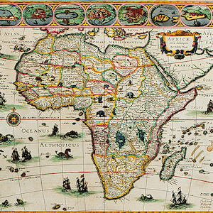
“Africae Novo” Map
The “Africae novo” map, from the early 1600s, allows us to think through the interpretation of one historical map. Unlike some historical maps that are mysteries, we know the origins of this one: it was produced by a famous Dutch cartographer, Willem Blaeu, and published in his 1630 atlas.

Commonwealth of Independent States, Map 1994
This map outlines the political territories that took the place of the Soviet Union after 1991.

Refractory (Clergy) Going to the Promised Land
Many refractory clergy left France to join other detractors, as this print shows, or wishfully encourages. However, this is an ambiguous image, which leaves open the possibility that rather than joining foreign monarchies, the clergy are crossing the river leading to Hell.

Map of Ichan Qala
This type of image is known as a map. Represented on this paper is the old, walled city that forms a part of the larger, contemporary city of Khiva, Uzebekistan. This image covers one half of one side of the page of the map.

Analyzing Maps
The modules in Methods present case studies that demonstrate how scholars interpret different kinds of historical evidence in world history. In the video historian Gerald Danzer analyzes maps of the world. In the primary sources menu below, you can examine two world maps two maps of the world.

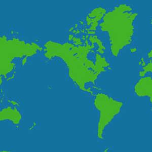
Mercator Projection, Eurasia Centered
The map is a Mercator projection that has been altered. Instead of placing North America in the center, the Eurasian land mass is in the middle. This map of the world suggests some of the ways the choices made by mapmakers have a significant impact on our understanding of the world.

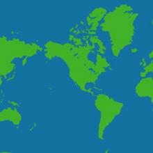
Mercator Projection
The map is a Mercator projection and is among the most common in use today. It places North America at the center.
This source is a part of the Analyzing Maps methods module.

Abstention Rate in Napoleonic Plebiscites
All regions of France did not support Napoleon equally. His rule aroused most enthusiasm in the east (a prerevolutionary border region crucial in the Napoleonic wars) and the center of the country, least in the west, which had long provided a home to royalist counterrevolution.