Geography

Tasveer Ghar (A House of Pictures)
This database would be most useful for instructors teaching modern South Asia and for students in college-level seminars.
The Gall-Peters Projection
Unsatisfied by the distorted view of the world that dominated the Western mind in the form of the Mercator Projection, James Gall and, later, Arno Peters engineered a new map in the 19th and 20th centuries.
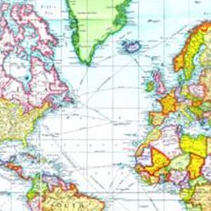
The Mercator Projection
Although the Flemish geographer and cartographer Gerardus Mercator's rendering of the earth has been criticized for the way it distorts reality, it was revolutionary in the way it organized space and distance.

Heilbrunn Timeline of Art History
The Metropolitan Museum of Art's Heilbrunn Timeline of Art History is a reference, research, and teaching tool for students and instructors interested in global art history or teaching global history through art.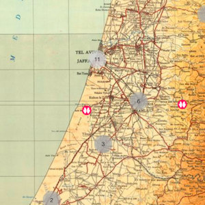
Palestinian Oral History Map
Drawing from thousands of hours of interviews from the Palestinian Oral History Archive (POHA), the map provides a stunning visual representation of Palestine in the 1940s, bringing interviewees’ memories of their lost homeland to life.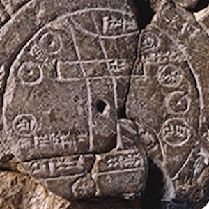
Babylonian Map Tablet
This ancient map depicts the known world as imagined by the Babylonians of the 6th century BCE. Like many ancient maps, this cuneiform tablet is concerned less with mathematically plotting space and direction than with simply capturing the various places and peoples in the world around Babylon.

Marshall Islands Stick Charts
The Marshall Island stick charts represent a unique and non-Western tradition of mapmaking.

Plan for the City of Moscow
This 1793 map of Moscow shows a relatively modest and compact city when compared to the sprawling metropolis of the 21st century. From this perspective, the viewer can see the remains of a fortification wall that once encompassed the entirety of the city.

Map of Poverty in Mexico
Maps are often designed to visualize more than just space and distance. This map, for instance, visualizes how poverty is distributed throughout the various Mexican states in hopes of identifying those areas most in need.

Ptolemy's World Map
Ptolemy was an ancient geographer working in Rome in the 2nd century AD.