Browse Primary Sources
Locate primary sources, including images, objects, media, and texts. Annotations by scholars contextualize sources.
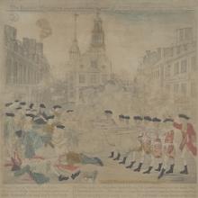
The Bloody Massacre Perpetrated in King Street, Boston, March 5, 1770
The events on the night of March 5, 1770, in Boston, Massachusetts, became known as the Boston Massacre and are often taught from the perspective of people like Paul Revere.
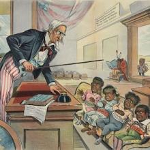
School Begins
This source comes from a period sometimes deemed the Age of American Imperialism. In 1899, this political ad was produced in New York. This image shows Uncle Sam, the personification of the U.S.
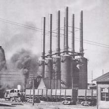
Showa Steelworks in Anshan (Northeast China)
Showa Steelworks, initially established as Anshan Ironworks in 1917, was located in Anshan, Liaoning Province, Northeast China, historically known as Manchuria. Anshan Ironworks was a subsidiary of South Manchurian Railway Company, a Japanese semi-state-owned enterprise that managed railways and other operations in Manchuria.
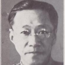
Weng Wenhao
Weng Wenhao (翁文灏, 1889-1971) was a distinguished Chinese geologist, politician, and educator who played a crucial role in shaping China's developmental state during the 20th century.
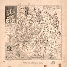
John Smith's Map of Virginia 1624
This map, created officially
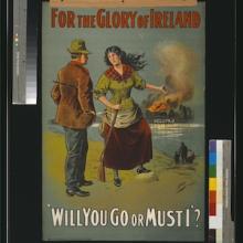
For the glory of Ireland
“For the Glory of Ireland” is a WWI propaganda poster published
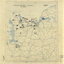
World War II Military Situation Map
This is a map of Normandy on the day of the Normandy Landing o
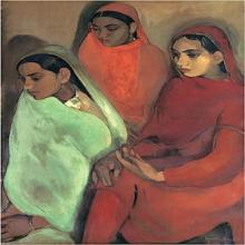
Amrita Sher-Gil: Young Girls, Group of Three Girls
Group of Three Girls (1935), and Young Girls (1932) were created by the early-twentieth century Indian artist, Amrita Sher-Gil.

Apolitical Intellectuals/ Intelectuales Apolíticos
Otto Rene Castillo wrote the poem “Apolitical Intellectuals” in 1967 in response to the Guatemalan Civil War, which lasted from 1960-1996.
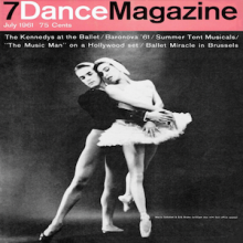
Maria Tallchief in Dance Magazine, 1961
This 1961 Dance Magazine cover depicts a photograph of ballet dancers Maria Tallchief and Erik Bruhn. The magazine advertises for upcoming performances at the Kennedy Center.
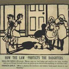
Suffrage Atelier Postcard, 1909
This propaganda postcard titled "How the Law ‘Protects the Daughters'" can be used to study European suffrage movements. The postcard was created by the group Suffrage Atelier, a pro-suffrage artisan collective in England which was founded in 1909.

Sympathy
Published in 1946 for an audience of affluent, book-buying families in Seoul, Grapes and Beads realistically describes the daily lives of children in the poorer countryside with affection and respect.
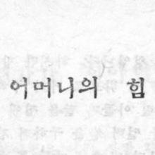
A Mother's Power
Published in 1946 for an audience of affluent, book-buying families in Seoul, Grapes and Beads realistically describes the daily lives of children in the poorer countryside with affection and respect.
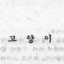
Cat (Korean Children's Story)
Published in 1946 for an audience of affluent, book-buying families in Seoul, Grapes and Beads realistically describes the daily lives of children in the poorer countryside with affection and respect.
Friendship
Published in 1946 for an audience of affluent, book-buying families in Seoul, Grapes and Beads realistically describes the daily lives of children in the poorer countryside with affection and respect.
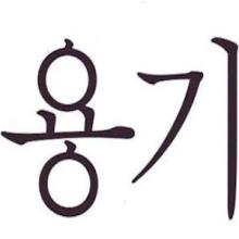
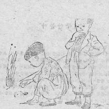
Courage
Published in 1946 for an audience of affluent, book-buying families in Seoul, Grapes and Beads realistically describes the daily lives of children in the poorer countryside with affection and respect.
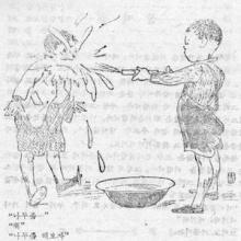
The Squirt Gun
Published in 1946 for an audience of affluent, book-buying families in Seoul, Grapes and Beads realistically describes the daily lives of children in the poorer countryside with affection and respect.
Lord Ismay Notice Regarding Indian Partition
The Partition of India was one of the most difficult, tension-filled political events of the twentieth century, causing millions of people to migrate within the Indian subcontinent and be killed due to resulting violence.
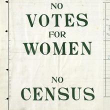
Census Protest for Women's Suffrage
This 1911 census form showcases one method of peaceful civil disobedience done by supporters of women’s suffrage in Britain during the early 20th century.

Ge'ez Script
Ge’ez script is a script used in modern-day Eritrea and Ethiopia that dates back to the 1st century CE.