Geography
Polynesian Oral Traditions
This collection compiled by Rawiri Taonui, a professor of Indigenous Studies, includes creation myths and stories about gods, the origin of humanity, and cultural heroes for several Polynesian cultures, such as Hawaii, Samoa, Tonga, Tahiti, and numerous others.
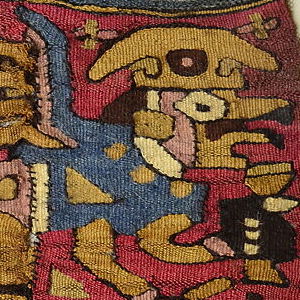
Coca Bag
This coca bag is from the Moche culture that existed in Peru between the period of 100 to 700 AD. The Moche are known for their ceramics, textiles, and metalworking practices, and this bag demonstrates the skill of Moche weavers.

Lapita Pottery from the Santa Cruz Islands
This pottery sherd dates from around 1000 BCE and is from the Lapita culture, the likely common ancestor of contemporary Polynesian cultures. This sherd was found in the Santa Cruz Islands, part of the Solomon Islands.
Short Teaching Module: Borderland Migration and Communities in Twentieth-Century West Africa
Cross-border mobility has created borderland cultures and led to the development of vibrant communities that in some cases have stretched across several states.
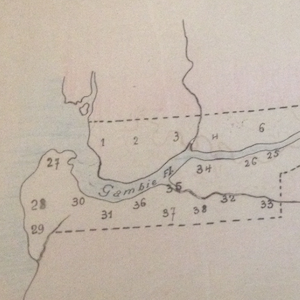
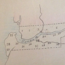
Map and Population Table for British Gambia, 1915-1918
Many people in West Africa fled across colonial boundaries to avoid military conscription in the late 19th and early 20th century. For example, during World War I, tens of thousands of people left the French colony of Senegal for neighboring British Gambia and Portuguese Guinea-Bissau.

Long Teaching Module: Caribbean Seafaring in the Archaic Age (2000-400 BC)
There have been many different approaches to studying seafaring in the past. We can look at the evidence of voyages in books written by prominent explorers or follow the maps maintained by successful prominent trading companies.

Least Cost Pathway Analysis Showing Movement Across a Landscape
These side by side charts show the basics of how least cost pathway analysis works in action. A geographic surface, landscape or seascape, is broken into standard size squares (or cells).
Analyzing Travel Records
In a way, all historical thinking and all historical writing deal with travel accounts.

Marco Polo’s Travels
Macro Polo lived from 1254 to 1324. He spent twenty-four years journeying through the Asian continent and left behind an impressive amount of documentation including travelogues of his adventures.

Travel writing of al-Biruni, 11th century Persian scholar
This image is taken from a page of al-Biruni work called Chronology of an Ancient Nations. al-Biruni was a native of Iran. He was a prolific Persian scholar. While he published works in a wide variety of subjects, the majority of those works were on the subject of astronomy.