Browse
Geography

Review
National WWI Museum and Memorial
Due to the immense amount of resources, we advise educators to enter the databases with an idea of what they want rather than attempting to browse.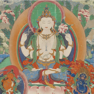
Review
National Museum of Asian Art
Because the museum is dedicated to Asian art, its educational resources are largely meant to teach students about art.
Review
World Heritage Site Map
The most well-known part of their work is the naming and administration of World Heritage Sites.
Review
African Studies Center
The Center hosts or links to resources on just about every African topic an educator might want to focus on in the classroom.
Review
New Netherland Institute
Due to New Netherland’s intersection across several themes such as globalism, Indigenous contact, enslavement history, transatlantic trade, imperialism, religion, it may be a useful case study for educators wishing to teach students about 17th-century Europea
Review
William J. Clinton Presidential Library and Museum
Overall, we found that though the Clinton Library offers a few lesson plans pertinent to global history, these are a bit underdeveloped and educators wishing to use them should strongly consider using supplemental materials

Review
Harry S. Truman Library and Museum
Among the student resources, teacher resources, and source databases, users will have access to materials with which they can discuss practically everything that happened in the world during Truman’s life (1883-1973) and even some things outside that time fram
Review
Minecraft Education
Because Minecraft offers such a wide variety of sources and topics, it can be incredibly helpful to teachers. However, because game-based play poses particular risks, such as the possibility that students will not learn and only focus on playing.
Review