Long Teaching Module: Caribbean Seafaring in the Archaic Age (2000-400 BC)


Overview
There have been many different approaches to studying seafaring in the past. We can look at the evidence of voyages in books written by prominent explorers or follow the maps maintained by successful prominent trading companies. We can use the objects left behind, showing who traveled where, when, and across what expanses of sea. We can also use the tools of digital humanities, such as computational methodologies, to evaluate unique texts, create maps, or produce interactive online engagement platforms. This can even extend to hypothesizing the location of sea voyages that took place several thousands of years ago. Computational archaeologists use digital tools to search the past, largely by using bringing in geography and a modern forecast of past environments as a base for broader understanding. Computationally-modeled canoe routes between known archaeological sites can demonstrate possible answers to the question of where people moved in the past, connecting with what we know from the physical material remains of where they lived. This teaching module uses a variety of sources to look at movement between the islands in the Caribbean in the Archaic Age (2000 - 400 BCE).
Essay
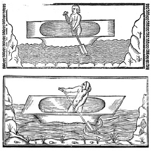
The sea has been a canvas for human mobility and interaction for thousands of years. When Europeans arrived in the Caribbean in 1492, they encountered many people who used the sea as a space for commerce, social interaction, and shows of strength. Depictions of Indigenous seafarers and their toolkits were less popular subjects to Europeans than were descriptions or drawings of engagements between people or of the local fauna, but they did make some written and visual references to canoe use.
We know from archaeological evidence that people used canoes to move themselves and materials between the Caribbean islands for approximately the past 6000 years. This evidence includes small fragments of canoe technology, such as canoes and paddles. Due to the environmental conditions in the Caribbean region and the fact that these objects were made from wood, however, there have only been a few fragments found. Researchers have also analyzed the archaeological record of material objects moved via canoe, and they have experimented with seafaring replication techniques to provide additional evidence.
Archaeologists studying the earliest inhabitants of islands in the Caribbean in large part focused on the analysis of stone materials that had been worked or moved by human hands. If the same type of stone remains are prominent across multiple islands, most likely people traveled to put it there. Identifying where a stone was quarried or processed, what is termed “lithic exchange,” can form a basis for judging where people may have begun or ended their journeys.
Experimental archeology has been conducted through collaborations between archaeologists and Caribbean community members who seek to connect to their Amerindian ancestors. Using reconstructions or modern canoes, they have tested the power of canoers working together, and how fast they can make the boats go, both helpful pieces of information in developing a seafaring model.
Computer models have been one of the most powerful tools to draw these elements together. Geographic Information Systems (GIS) have been a driving force in computational archaeological understandings of the past. GIS allows researchers to pinpoint to a meter by meter level where objects are found or buildings are situated, which has helped to place the past in a spatial context. Building on these basic advancements in map building, computers have run algorithms that indicate possible past human interactions with landscapes and seascapes. Since the 1990s computers have been used to answer questions about the visual prominence and object placement within landscapes, the process of resource procurement or settlement, and the likelihood that two groups of people were connected based on the similarity between the resources they used and their cultural materials. Most relevant to the discussion of moving between specific island sites across a sea is computationally modeling least cost pathways.
Least Cost Pathways Analysis uses modern geography to inform the plotting of pre-historic connections between specific places. To judge how far someone can move in a set time, a surface needs to be created based on the factors aiding or prohibiting movement, such as slopes of hills or sea currents. This is called a cost surface. These models can be viewed as environmentally deterministic, as they assume that humans will only want to move in the direction that is easiest, which is not always the case. However, modeling pathways can serve as a way to help identify new areas to observe or ask new questions about who moved where and why.
The cost surface created to analyze sea travel is made by combining wind and current information generated by the National Oceanic Atmospheric Administration (NOAA). These surfaces have high cost areas of strong current moving against the direction of travel as well as low cost areas where the current moves the modeled canoes. This helps identify where corridors of movement may have existed between what are known archaeological sites. Combined with the values of the speed of canoes provided by experimental archeology groups, calculations can be made about travel based on real world constraints.
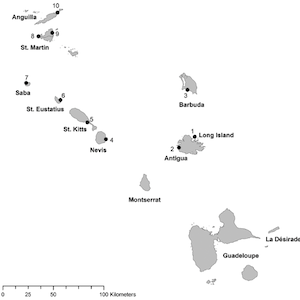
The pathways discussed in this module are based on a least cost isochrone model, in which the algorithmic model searches for the least cost path by creating bands that cover the same distance in a set amount of time from a start point. Once the shortest distance between a start point and bands is determined, a new start is generated at that point and a new band is created. These bands of set distance are repeated until the end point falls within them, the shortest distance across all bands is then determined to construct the least cost pathway. Start points used in this example fall on either side of the island of Antigua, a known producer and consumer of a prominent lithic material in the Archaic Age. While one might expect canoers to travel close to the coast of the island, in many cases extremes in the force and direction of wind and currents at different times of the year end up pushing canoes toward other islands. This is shown in one the sources, which depicts two different routes between the different points on the coast of Antigua that pass by different sections of Barbuda’s coastline.
The pathways modelled for early seafaring routes in the Caribbean show a preference for moving with the current and using a well-timed stopping place when necessary. While these might be common sense navigation strategies, in practice they indicate foundational connections between early habitation sites on islands and subsequent commercial sites that appear along the routes between these established communities. Indeed, these modeled routes seem to indicate a sustained practice of navigation influenced by the currents and reinforced by the interests of the people who traveled on them.
These islands are also rich in archeology, with excavation data demonstrating a close connection with materials originating in Antigua. Could these excavations also show the remains of towns that existed to provide shelter to those knocked off course? Could they provide evidence of decedent communities who used these convenient rest points as stopover points between zones of exchange? At this time there is no definitive answer.
Together, pathways analysis and archaeology show us that the islands were perhaps more connected than one might first assume by looking at present day maps. From research connecting various practices of stone tool or ceramic construction, we know that prior to 1492 the islands were much more connected via the coastal avenues than via interior landscapes. Looking at the routes connecting past areas of activity shows that the construct of islands being divided into separate nation states is something new. Today there are still many independent sea crossings between islands out of the view of state powers, replicating those of the past. Those past voyages have also been used to create elementary and middle school level class exercises, with the aim of breaking down national bearers to focus on a more connected past between islanders.
This short example of research into past mobility practices shows that an interdisciplinary focus is key to understanding the past. The written historic record is only part of the story. Both archaeological theory and computational methods help us put together the context for clues found in objects buried in the ground, written texts, NOAA generated climate models, and modern recreations of seafaring practices. When asking questions of the past, it is vital to check multiple sources and use multiple methodologies.
Primary Sources
2 Prints of a Sole Amerindian in a Canoe
Annotation
Remains of the Stargate Canoe
Annotation
Least Cost Pathway Analysis Showing Movement Across a Landscape
Annotation
Tracing Canoe Pathways in the Lesser Antilles, 2000 BE - 400 BC
Annotation
Credits
Emma Slayton earned her PhD at the University of Leiden in archaeology in 2018. Emma currently serves as a Data Curation, Visualization, and GIS Specialist at the Carnegie Mellon University Libraries. As an archaeologist, she is focused on using computer modeling to hypothesize the location of early canoe routes in the Caribbean. She has experience working with GIS and other data visualization tools. This knowledge aids her work at CMU, where she plans workshops and other content to promote the use of various data visualization methods, tools, and techniques.