Travel
Excerpt from Travels in Africa
Imperialism is one of the most pertinent topics in relation to travel and exploration. By the end of the 19th century, the spread of European imperialism had made many areas of the world “safe” for women travelers.

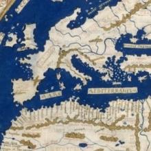
Short Teaching Module: European Maps of the Early Modern World
I use images of three historical maps for topics on colonial exploration and for interpreting historical evidence in undergraduate courses on history and historical methodology. I have several aims in using the maps.

From John Bartholomew, Literary and historical atlas of America
This unusual map appeared in a 1911 atlas of America by John George Bartholomew, a prestigious Scottish cartographer and geographer. In this map Bartholomew dramatized the provincialism of European cartography three centuries earlier.

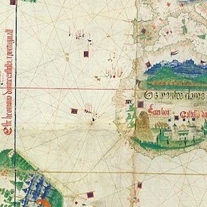
Cantino planisphere
The famous Cantino planisphere was made in 1502 by an anonymous Portuguese official at the request of Alberto Cantino, an Italian agent in Lisbon of Ercole d’Este, Duke of Ferrara.

World map by Henricus Martellus
Henricus Martellus was a German geographer and cartographer who worked in the Italian city of Florence from 1480 to 1496. His book of 1490, Insularium Illustratum ("Illustrated Book of Islands"), in which this map appeared, was widely circulated for two reasons.

Southeast Asia in the Ming Shi-lu
A legendary repository for scholars of Southeast Asia and researchers interested in the Chinese World Order, Southeast Asia in the Ming Shi-lu is a veritable treasure trove of information on a dynamic region during a period of transcendental change.
Beyond the Bubble
Beyond the Bubble is a fantastic initiative that provides educators with an array of thoughtful and easily implementable history assessments.
Logan Museum of Anthropology
With almost 5000 items digitised at the moment and more to come in the near future, this will definitely be a useful site to keep an eye on.
Imágenes y relatos de un viaje por Colombia
The experience of exploring the manuscript is enriched by an impressive array of visual accompaniments and multimedia resources such as maps, image galleries, infographics, animations, and audios.