Travel

Studs Terkel Radio Archive
As stated on the tin, the Studs Terkel Radio Archive is dedicated to digitising and archiving the numerous radio programs that Louis “Studs” Terkel (1912-2008) made throughout his prolific career.
Babylonia Collection Yale
The versatility of the collection makes it useful for any discipline that approaches the material to have a chance of finding artifacts or useful resources either for research or educational purposes.
Livingstone Online
While the site is primarily dedicated to digitising the famed British explorer’s works, Livingstone Online is far more than a mere repository of primary sources.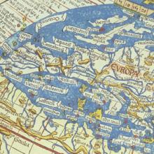
Analyzing Maps
The map is one of the oldest forms of nonverbal communication. Humans were probably drawing maps before they were writing texts. Mapmaking may even predate formal language. As far as historians and geographers can determine, every culture in every part of the world uses and makes maps.

A History of the World in 100 Objects
Overall A History of the World in 100 Objects is a great resource to teach world history through visual culture in an accessible and succinct format for both school and college-level classes.
Map of the Union Pacific Railway
This 19th century map illustrating the many places one could travel on the Union Pacific Railway is the product of a multitude of choices made by the mapmaker.

Tasveer Ghar (A House of Pictures)
This database would be most useful for instructors teaching modern South Asia and for students in college-level seminars.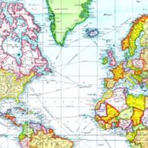
The Mercator Projection
Although the Flemish geographer and cartographer Gerardus Mercator's rendering of the earth has been criticized for the way it distorts reality, it was revolutionary in the way it organized space and distance.

The Jingban tianwen quantu Map of the World
Like many maps in the pre-modern and early-modern world, this map from China at the end of the 18th century reflected a deeply egocentric worldview.

The Turin Beatus Map of the World
Before the modern age, maps offered more than just an objective, geographical survey. Often, as is the case with this world map from the 12th century, they also conveyed a set of stories that shaped the worldview of its viewers.