Travel

Minecraft Education
Because Minecraft offers such a wide variety of sources and topics, it can be incredibly helpful to teachers. However, because game-based play poses particular risks, such as the possibility that students will not learn and only focus on playing.
Naval History and Heritage Command
Among the archive's digital collections users can find oral histories, biographies, underwater archeology resources, and infographics.Al-Umari’s Account of Mansa Musa’s Visit to Cairo
Mansa Musa was the leader of the Mali empire in the fourteenth century and reportedly the wealthiest person – allegedly ever. The empire covered modern-day Mali and parts of Guinea, Senegal, Mauritania, and the Gambia, and Mansa Musa expanded the territorial claim to include Gao and Timbuktu.

Te Paranihi, or Maori War Canoe
Te Paranihi is a 17-meter (55 feet) war canoe, or waka taua, from the Maori culture indigenous to New Zealand.

Lapita Pottery from the Santa Cruz Islands
This pottery sherd dates from around 1000 BCE and is from the Lapita culture, the likely common ancestor of contemporary Polynesian cultures. This sherd was found in the Santa Cruz Islands, part of the Solomon Islands.

Long Teaching Module: Caribbean Seafaring in the Archaic Age (2000-400 BC)
There have been many different approaches to studying seafaring in the past. We can look at the evidence of voyages in books written by prominent explorers or follow the maps maintained by successful prominent trading companies.

Tracing Canoe Pathways in the Lesser Antilles, 2000 BE - 400 BC
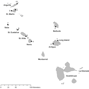
These maps show two constructed least cost pathways between Flinty Bay on Long Island just off the coast of Antigua (the right end of the line) and Jolly Beach on Antigua (the left end of the line).

Least Cost Pathway Analysis Showing Movement Across a Landscape
These side by side charts show the basics of how least cost pathway analysis works in action. A geographic surface, landscape or seascape, is broken into standard size squares (or cells).

Remains of the Stargate Canoe
This image showcases one of the few remains of a canoe found in the Caribbean. The ‘Stargate’ canoe, found in a blue hole—a large marine cavern--on the island of South San Andros in the Bahamas, represents only the tip of the canoe.
