Trade

A Naval Encounter between Dutch and Spanish Warships
Spanish galleons were large ships specifically built to carry a huge amount of cargo across the vast distances of the Spanish maritime empire. The Manila Galleon Trade is a common topic in world history courses and represents the first truly global trade in world history.

Balclutha
Balclutha was built in 1886 on the River Clyde near Glasgow, Scotland, for Robert McMillan, a Glaswegian shipbuilder who occasionally owned ships as a side-business.

HMM Algeciras
As of the beginning of 2021, the Algeciras class is the largest container vessel in the world, able to carry nearly 24,000 TEU (twenty-foot long containers). It is constructed by Daewoo Shipbuilding and Marine Engineering and owned by Hyundai Merchant Marine.

Short Teaching Module: Premodern Chinese Maps and the Global Maritime World
Premodern Chinese maps offer fascinating sources for teachers and students of world history.

Selden Map
The Selden Map held by the Bodleian Library in Oxford, where it has been kept since 1659. This beautifully illustrated manuscript map shows East and Southeast Asia and marks maritime trading routes in the form of lines across the region.

Guang yutu map
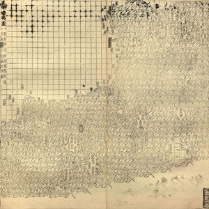
The map of the “South-Eastern ocean barbarians” from the 1558 edition of the atlas Guang yutu. This atlas is divided into two parts, the first one deals with the geography of China, the second one with the Chinese borderlands, thematic maps, and maps of non-Chinese regions.

Primer: Technology
Technology, broadly defined, denotes not only transformative innovations but the whole spectrum of tools, skills and artifacts with which human societies construct their worlds.

Akan Gold-Weight in the Shape of the Sankofa Bird
These intricate figurines, made by skilled West African smiths, were measuring instruments central to world flows of capital and commerce through medieval and early modern times.

Short Teaching Module: Shared Space, Shared Experiences: Transnational Water Management around the Great Lakes
World historians sometimes work within a single sub-field, such as migration history or gender history, but they can also bring sub-fields together, as their perspectives, methods, and subject matter cross boundaries.

Primer: The History of Globalization
Globalization, defined here as the integration of an interdependent economy that simultaneously enhances cultural exchanges relying on the mobility of people, animals, plants, pathogens, objects, and ideas, is a useful concept for exploring connections across space and time.