Europe
Mikhail Gorbachev’s Resignation Speech
This is a transcript of Gorbachev’s resignation speech. This speech signified the complete end of the Soviet Union. According to the speech, what reasons does Gorbachev give for his resignation? What is the overall tone of this document? Why do you think Gorbachev uses this tone?
Long Teaching Module: Border Changes of the Soviet Union
Border changes have been a central part of 20th century European history. This lesson will examine a few key maps and documents that explore the creation, expansion, and dissolution of the Soviet Union.
The Alma-Ata Declaration
This document is a translation of the Belovezh Accords, the agreement which essentially declared that the Soviet Union ceased to exist. Those who signed it agreed to form a Commonwealth of Independent States (CIS). Which states were signatories of the Belovezh Accords?

Act of Declaration of Independence of Ukraine
This source is one example of a former Soviet republic declaring its independence from the Soviet Union. Who created this document? What reasons does the document creator give for wanting to secede from the Soviet Union?

History of NATO Expansion Map
This map shows the expansion of NATO over time. Have students identify the most recently states to join NATO. Which states have joined NATO after the collapse of communism? Which of these newer NATO states had been Soviet satellite states as opposed to full republics of the Soviet Union?

Cold War Europe Military Alliances Map
This map illustrates which states in Europe belonged to NATO or the Warsaw Pact military alliance. The white states were neutral. This map illustrates the infamous Iron Curtain and the split between West and East. Which of these states belonged to the Warsaw Pact?

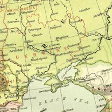
Map of Europe, 1918
This map illustrates European borders prior to the start of WWI in 1914 with black lines and new states formed by the First World War in red. As the map illustrates, a number of states became independent from Tsarist Russia. What new states were these?
Primer: A Global History of Higher Education
Histories of higher education tend to focus on a single institution – the university biography – or address the subject within the context of the nation-state.

“The South African College and Its ‘Old Boys,’” 1886
The 1886 article, “The South African College and Its ‘Old Boys’,” provides an example of how universities extended their influence within an empire (or globally) through alumni and their expertise.
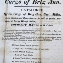
Short Teaching Module: Nineteenth-Century American Trade on Zanzibar
Although American merchants often fade from historical narratives after the eighteenth century, they remained influential actors in the United States and abroad.