Modern (1800 CE - 1950 CE)
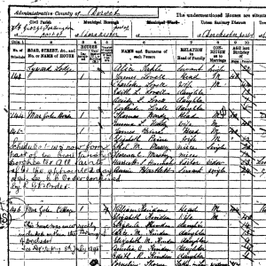
Census of England, 1891
The census of the United Kingdom was the tenth census and was taken on April 5, 1891.

“Big Business Banishes the Flapper"
The “flapper” craze overtook the western world in the early 1920s and was spearheaded by young women intent on bucking cultural n
Mandate for Palestine
The Mandate for Palestine was a legal document that established the United Kingdom as a Mandatory in charge of Palestine and Tran

Kasai Velvet, Democratic Republic of the Congo
Despite its name, Kasai velvet, or velours du kasai, is not actually a velvet.
Analyzing Primary Sources on Women in World History
Traditionally, historical writing focused on elites and often rendered women invisible unless they were queens or empresses.

Business contract between Richard P. Waters and his Omani-Zanzibari trading partner, Esau bin Abdul Rahman
This contract represents how business was typically transacted in Zanzibar and throughout the Omani Empire.

Short Teaching Unit: The Omani Empire and the Center of the Emerging Global Economy, 1500-1850
This essay pushes back against European-dominated narratives of world history to suggest that the Omani Empire was a crucial space for the emergence of our present-day system of global capitalism.
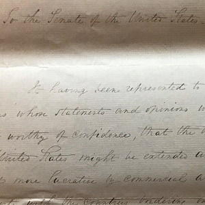
A letter from U.S. President Andrew Jackson to the Senate Dated Washington, May 30, 1834
A letter from President Andrew Jackson to the Senate where the President discusses the possibility of extending US trade. Jackson was particularly interested in the potential trade connections with areas around the Indian Ocean.

List of Foreign Arrivals in the Port of Zanzibar from the 16th September 1832 to 26th May 1835
This is an ostensibly mundane document that contains a tremendous amount of information for interpreting the global dynamics of this period of history, all while peering out into the world from the tiny island of Zanzibar.
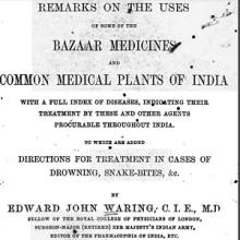
Short Teaching Module: Teaching the Intersection of Gender and Race through Colonial Medical Texts
This module focuses on medical texts written by British doctors working in India and their gendered and racial categorization of ailments and diseases.