Browse
Geography

Review
World Digital Library
The World Digital Library is a free online archive of over 19,000 culturally significant primary source materials from around the world.
Review
Afriterra, The Cartographic Free Library
The maps can be used as important teaching tools for courses on many topics: African history; Atlantic World history; the slave trade; the era of European expansion; environmental history; and military history.![Thumbnail image of Descobrimento do Brasil [Discovery of Brazil] by Oscar Pereira da Silva](/sites/default/files/brazil-thumbnail.jpeg "Thumbnail image of Descobrimento do Brasil [Discovery of Brazil] by Oscar Pereira da Silva")
Review
United States and Brazil: Expanding Frontiers, Comparing Cultures
The goals of the site are to illuminate Brazilian history, to explore the historical and cultural interactions between Brazil and the United States, and to draw attention to the similarities and differences between these two societies.
Review
Afro-Louisiana History and Genealogy, 1718-1820
The Slave Database offers information on more than 100,000 slaves and the Free Database has records on more than 4,000 slave manumissions.
Review
Southeast Asia Visions Collection
The range of sources and their ready accessibility also provides valuable material for work on diverse Southeast Asia topics related to local, regional, and global history.
Source
My Harvest Home
John Glover is considered to be one of the best Australian landscape painters of the early colonial period. He painted My Harvest Home in 1835 and it depicts Patterdale Farm in northern Tasmania, the farm Glover established in 1832 through a land grant from the Tasmanian Government.

Review
Digital South Asia Library
The information and source materials presented on this site are extremely wide ranging, rare, and occasionally quite specific. Given the amount of content, this specificity should be seen as an asset rather than a drawback.
Review
Around the World in the 1890s: Photographs from the World's Transportation Commission, 1894-1896
Although these photographs are immediately useful to any discussion of 19th-century travel, they also provide an important look at the nature of colonialism and industrialization in many of the regions to which Jackson traveled.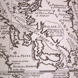
Source
Map of Malacca, Châtelain
This is a detail of a map depicting the port of Malacca and the surrounding territories from the Atlas Historique, an expansive Dutch encyclopedia compiled by Henri Abraham Châtelain and first published between 1705 to 1720.
Source
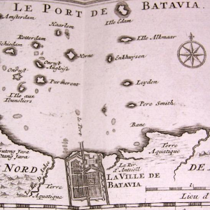
Map of Batavia, Châtelain
This is a detail of a map depicting the Dutch stronghold of Batavia from the Atlas Historique, an expansive Dutch encyclopedia compiled by Henri Abraham Châtelain and first published between 1705 to 1720.