Middle East

Minecraft Education
Because Minecraft offers such a wide variety of sources and topics, it can be incredibly helpful to teachers. However, because game-based play poses particular risks, such as the possibility that students will not learn and only focus on playing.Al-Umari’s Account of Mansa Musa’s Visit to Cairo
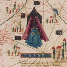
Mansa Musa was the leader of the Mali empire in the fourteenth century and reportedly the wealthiest person – allegedly ever. The empire covered modern-day Mali and parts of Guinea, Senegal, Mauritania, and the Gambia, and Mansa Musa expanded the territorial claim to include Gao and Timbuktu.

Analyzing Travel Records
In a way, all historical thinking and all historical writing deal with travel accounts.

Marco Polo’s Travels
Macro Polo lived from 1254 to 1324. He spent twenty-four years journeying through the Asian continent and left behind an impressive amount of documentation including travelogues of his adventures.
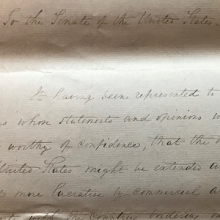
Mandate for Palestine
The Mandate for Palestine was a legal document that established the United Kingdom as a Mandatory in charge of Palestine and Tran
Short Teaching Unit: The Omani Empire and the Center of the Emerging Global Economy, 1500-1850
This essay pushes back against European-dominated narratives of world history to suggest that the Omani Empire was a crucial space for the emergence of our present-day system of global capitalism.
Short Teaching Module: Nineteenth-Century American Trade on Zanzibar
Although American merchants often fade from historical narratives after the eighteenth century, they remained influential actors in the United States and abroad.

Outward Cargo Manifest of the Rowena, 1841
Cargo manifests and other shipping records offer a tangible glimpse into expansive commercial networks, reminding observers of the physical goods underwriting long distance trade.
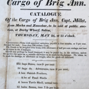
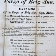
Advertisement for the Auction of the Ann’s Cargo, 1827
This flyer advertises the Ann’s 1827 arrival in Salem, Massachusetts, after making one of the first American trips to Zanzibar.
Short Teaching Module: Examining Early Genoese Voyages through Maps
The medieval Genoese ranged from China to the Atlantic, and their experience in navigation, the sugar industry, and the slave trade were the elemental foundation of Iberian colonial expansion.