Browse
Middle East

Source
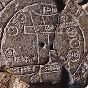
Babylonian Map Tablet
This ancient map depicts the known world as imagined by the Babylonians of the 6th century BCE. Like many ancient maps, this cuneiform tablet is concerned less with mathematically plotting space and direction than with simply capturing the various places and peoples in the world around Babylon.

Review
Digital Archive: International History Declassified
An extensive repository that collects declassified archival records from all over the world, the Wilson Center's Digital Archive: International History Declassified is an essential resource for scholars, educators, and students interested in international history.
Review
Global Architectural History Teaching Collaborative
Perhaps most interesting and relevant for world history teachers and students are the modules that make connections across space and time.
Methods
Analyzing Material Objects
The modules in Methods present case studies that demonstrate how scholars interpret different kinds of historical evidence in world history. This module developed by historian Daniel Waugh explores how historians interpret material objects to better understand the past.

Source
A gold dinar of Abd al-Malik minted in Damascus in 697/98
Historians use coins to find evidence of change over time. This dinar coined in 697 or 698 was minted in Damascus by the Umayyad Caliph Abd al-Malik ibn.

Review
Edsitement
The site contains over 500 lesson plans in a variety of humanities related subjects including history, literature, and art.
Review
Map Section Image Database
The Walker Collection comprises 135 maps, printed between 1511 and 1774, that cover Asia Minor and surrounding areas including the Mediterranean, the Middle East, and the Balkans.
Review
Abdul-Hamid II Collection Photography Archive
Teachers and students of the history of children and youth will be particularly taken by the vast array of education-themed photographs, which reveal a strong emphasis placed on schooling by the Ottoman Empire at the time.
Review
Topkapi Museum
Such images of Islamic art from the Topkapi museum can not only bring to life periods of Ottoman history, but also the variety and brilliance of Islamic art, both of which are useful to the teaching of world history.
Review