Short Teaching Module: Examining Early Genoese Voyages through Maps
Overview
The medieval Genoese ranged from China to the Atlantic, and their experience in navigation, the sugar industry, and the slave trade were the elemental foundation of Iberian colonial expansion. The ancient Phoenicians may have accomplished the circumnavigation of Africa, and here we find evidence of western Europeans attempting it long before the famous voyage of Vasco da Gama in the late fifteenth century. This curriculum contribution uses medieval cartographic evidence to illustrate this often hidden history, and to assist fellow teachers in encouraging our students to go beyond textbook accounts, and to grapple with conflicting and contested narratives about the rise of Europe and why it continues to matter for us today, as scholars and citizens.
Essay
Our students learn early that Columbus was Genoese, but even historians have a difficult time explaining why this would be important, either about the Genoese or about Columbus. Yet it was no accident that it was a Genoese who triggered the process of western European global expansion. When Vasco da Gama made landfall at Calicut in May 1498, his crew were met by two Muslim merchants from Tunis, who spoke with them in Castilian and Genoese; and a diarist aboard noted that Muslim mariners in the Indian Ocean had “Genoese needles” by which to steer. Long used by the Arabs, the art of celestial navigation was, for Europeans of this period, in its infancy. Columbus posed as an expert and called it a mystery to the uninitiated, but the testimony from his own journals demonstrates that the method of finding latitude from a meridional observation of the sun was unknown to him.
As statues of Columbus topple, it’s a good time to revisit with our students his contested legacy. Whether we lionize him, as many in past generations have, or demonize him, as we tend to do today, we are missing something important: people like Columbus – other Genoese navigators, pirates, and slave-traders – were everywhere in the Mediterranean and Atlantic worlds, not only in the late fifteenth century but for two centuries before this. For example, the navigator students usually encounter in textbooks as John Cabot was the Genoese Giovanni Caboto.
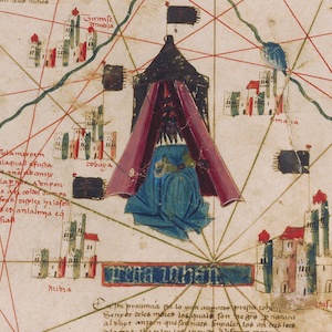
In this teaching module, I offer two maps to explore in the classroom, but there are many others. Copyright issues prevent publication of these maps here, but please reach out to me by email for digital copies of these other maps mentioned, to be used for educational purposes only. The first map here is from a fifteenth-century Catalan Atlas, now in a library in Modena, Italy (Biblioteca Estense Universitaria). If you have the opportunity to project it on a big screen, your students will be able to enjoy and explore this rich source. It’s useful in a variety of lessons ranging from basic geography to more comparative assignments for advanced students. Which areas of the world are most accurately depicted? Where does the author’s grasp of geography begin to wane?
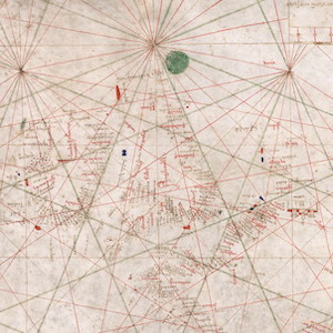
It’s important to note that this atlas did not represent the cutting edge of geographic knowledge. Two centuries before Columbus’s fateful first voyage, in 1291, two Genoese brothers departed Genoa and sailed through the Mediterranean into the Atlantic, intending to reach India by circumnavigating Africa. You can find much information about the Vivaldi expedition online and in the article included in the section on further reading. Like many other maps of this period, the Catalan Atlas depicts the island of Lanzarote in the Canaries with the Genoese flag of St. George (white with a red cross). Zoom in on the Canaries off the coast of what is now Morocco, and have the students find the island of Lanzarote, named after the mysterious Genoese figure Lanzarotto Malocello. Most maps of the fifteenth and sixteenth centuries continue to include the Genoese flag and to call the island some version of Lanzarote (Lancilotto, Lansalot, or Lamcarota). Because this island is still named after him, scholars have almost universally assumed that Lanzarotto was the first western European in the Canaries; yet like Amerigo Vespucci, who managed to baptize a new world with his name, Lanzaroto need not have been the first European in the Canaries. Our second map gives us a better view of the Canaries: this is a 1385 map of Guglielmo Soler, a Majorcan cartographer, which ranges from the Black Sea to the Atlantic (see also the close-up of this map, highlighting the island of Lanzarote).
The early period of oceanic exploration is shrouded in mystery, and students will often encounter textbooks riddled with errors on this point. For example, Portuguese claims to have discovered, in the 1420s, the Madeira and Azores islands and two uninhabited islands in the Canaries are contradicted by an Italian presence on these islands long before. The earliest names of islands in the Canaries, Madeira, and Azores archipelagoes were all Italian; and when Portuguese colonization of Madeira began in the 1420s, there was already a well-established sugar industry there founded by Italians. Luca Cassano was among the Genoese who transported slaves back to Portugal and to the sugar islands, and indeed slaving was the process by which the west African coastline was explored. Luca disappeared without a trace on one of his Atlantic voyages, but the Genoese slave-based sugar plantations of the near Atlantic islands from Madeira to Cape Verde would soon become the model for the turbo-charged Caribbean variety.
The Portuguese claimed that the captain Gil Eanes in 1434 was the first to pass Cape Bojador on the west African coast south of the Canaries. In 1443, King Alfonso V of Portugal granted Prince Henry a monopoly on navigation south of Cape Bojador, asserting that no map recorded anything beyond it; and scholars today continue to assert that the Canaries were the southern limit of European penetration of the Atlantic until this point. Yet several fourteenth-century maps contain details of the lands beyond Bojador. The Genoese Giovanni da Carignano had marked a kingdom of Gozola below Bojador; and an anonymous Genoese world map of the late fourteenth or early fifteenth centuries is the oldest extant to show Africa as circumnavigable, to mention the Canaries, Madeira, and Azores archipelagos, and to attempt to chart the Gulf of Guinea. The 1367 portolan of Francesco and Domenico Pizzigano shows lands beyond Bojador, and a map ascribed to the Catalan Ramon Puiades ranges from the Persian Gulf to Scandinavia, and from the Gulf of Aden to Gambia, mentioning a King of Mali, Lord of Guinea. The Catalan Atlas of 1375 refers to the trade routes and markets of the Niger basin and records a 1346 voyage by Jaume Ferrer along this coast in search of a river of gold.
Since at least the late thirteenth century, European navigators had put the circumnavigation of Africa to the test. The Vivaldi expedition had tried it; and in the early fourteenth century, the Dominican William of Adam had believed the voyage possible. The anonymous Genoese who had constructed a world map in the late fourteenth or early fifteenth century was part of a network of learning in which it was a prevailing idea that Africa was circumnavigable; and the Venetian mapmaker Fra Mauro, who died in 1464, also claimed that Africa could be circumnavigated. Recovering this history through maps can be an exhilarating way for students to bypass textbooks and to dispel misconceptions and myths at the heart of the widely accepted narrative of the rise of Europe.
Further reading: “Outsourcing the Colonial Project: the Genoese role in Iberian expansion.” World History Bulletin 35, no. 2 (2019): 15-48.
Primary Sources
Catalan Map of the World, c.1450
Annotation
Nautical Chart, 1385
Annotation
Credits
Padraic Rohan is Humanities & Sciences Dean's Fellow and Lecturer in the History Department at Stanford University. He teaches across European, Islamic, and world history, and has worked as a journalist and researcher in Turkey and throughout the Middle East, reporting from Iraq and Syria