Asia
Short Teaching Module: History of the Pacific Ocean
Scholars of Pacific history explore how people build lives dependent on the ocean, how maritime connections create communities, and how humans and the environment shape each other.
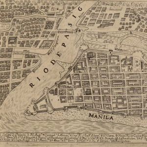
Map of the Philippines, 1734
The city of Manila is a perfect place to think about the importance of cities to world history.

Chinese Junk, early 18th century
Junks encompass a range of different ships that were essential for maritime trade in East Asia, Southeast Asia, and the Indian Ocean for centuries. Original junks built in China were likely inspired by the design of ships visiting Chinese ports from Austronesia and Southeast Asian archipelagos.

Short Teaching Module: Premodern Chinese Maps and the Global Maritime World
Premodern Chinese maps offer fascinating sources for teachers and students of world history.

Selden Map
The Selden Map held by the Bodleian Library in Oxford, where it has been kept since 1659. This beautifully illustrated manuscript map shows East and Southeast Asia and marks maritime trading routes in the form of lines across the region.
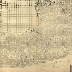
Guang yutu map
The map of the “South-Eastern ocean barbarians” from the 1558 edition of the atlas Guang yutu. This atlas is divided into two parts, the first one deals with the geography of China, the second one with the Chinese borderlands, thematic maps, and maps of non-Chinese regions.
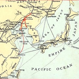
Southern Manchuria Railway (1906-1945)
The world’s earliest locomotive-operated railroads, short stretches transporting coal and ore locally from mines to factories and furnaces, were developed in Britain between 1800 and 1825.

Coffee Production in the Dutch East Indies
This is a page from an educational print for children called Gambar-Gambar akan Peladjaran dan Kasoekaän Anak-anak dan Iboe-bapanja (Prints for the Benefit and Pleasure of Young and Old).

Long Teaching Module: Masculinity and Femininity in the Mongol Empire
This module examines ideals of masculinity and femininity among the Mongols, the Central Asian nomadic pastoralists who in the thirteenth century under their leader Chinggis Khan created the largest land-based empire the world has ever seen.

Sorghaghtani Beki and Tolui
In this illustration from Rashid al-Din’s Compendium of Chronicles Sorghaghtani Beki and Tolui sit together on a pillowed throne.