Asia

Cartoon Depicts Debate at Hasting's Impeachment Trial, 1788
Printed in London in 1788, this satirical print was a response to the debate unleashed by the impeachment trial of Warren Hastings, the former and first Governor General of India, as well as the impeachment proceedings initiated against Elijah Impey, the former and first Chief Justice of the Supr

Cartoon Mocking British Policy toward India, 1788
This satirical print from 1788 constituted a cartoonist’s effort to make sense of and criticize growing governmental control over territories in South Asia.

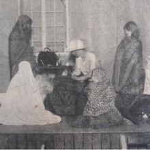
Photograph of “Indian Tableaux at Endon”
This photograph, which was originally published in the G.F.S. Magazine in September 1923, is from a tableau performed by members of the Girls’ Friendly Society (GFS), which was a youth organization akin to the more popular Girl Guides.
Long Teaching Module: Exploring Empire through the Lens of Childhood and Gender
As European empires expanded at the end of the end of the nineteenth century, imperialism came to permeate everyday life and had a pervasive influence on childhood, shaping everything from education to sports and literature.

Calendar from Cham manuscript, early 20th century
An image of the Cham calendar from an early 20th century Cham manuscript. The column on the left and top row indicate measurements of months of the calendar drawn from the Islamic lunar calendar. Numerals written in Cham script in the middle are symbolic of the Cham Hindu solar calendar.
Ariya Cam Bini
Ariya Cam Bini is one of the few ariya that has little to no historical references in the poem. It is possible to deduce from the language of the poem and from the study of extant versions of the manuscript that its origins likely lie in the 19th century.
Short Teaching Module: Ariya Cam Bini, a 19th century Cham Poem
Ariya Cam Bini is a 19th–century epic poem written in the Austronesian Cham language of mainland Southeast Asia. The poem comes from the area called Pāṇḍuraṅga or Nâgar Cam, a pluralistic society in terms of culture, religion, and identity.


Heading of east portal Tunnel No. 8
In the late nineteenth century, multiple transcontinental railroads were built across the United States and Canada. These were Pacific projects twice over: Each railroad aimed to open new routes for global trade with Asia, and each depended heavily on Asian laborers for their construction.
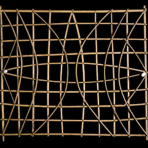
Marshall Islands stick chart
Across millennia, Pacific people voyaged out to sea and settled the ocean’s thousands islands and atolls, linking new discoveries back to existing territories.