War
Short Teaching Module: Borderland Migration and Communities in Twentieth-Century West Africa
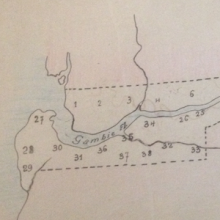
Cross-border mobility has created borderland cultures and led to the development of vibrant communities that in some cases have stretched across several states.

U.S. targets Indian activist, Taraknath Das
During World War I, U.S. and British officials expanded a transimperial surveillance apparatus designed to police enemy aliens and foreign threats. U.S.
Short Teaching Module: Connecting the French Empire
For a long time, historians tended to study colonial empires of the 19th and 20th centuries one colony at a time, or through the relationship of one colony to its metropole.
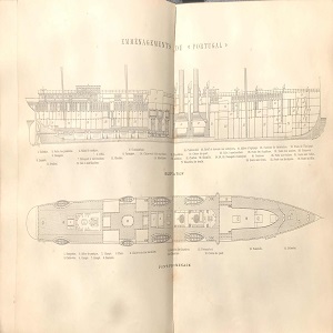
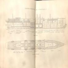
Ship Plan of a Late-19th Century Steamship
This ship plan from the late-19th century offers a partial view of spatial arrangements within a Messageries steamship.
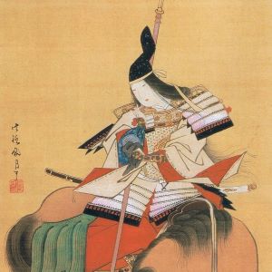
Tomoe Gozen
Tomoe Gozen was a Japanese female samurai that lived during the late twelfth century, or late Heian period, in Japan.

The Bayeux Tapestry
Most likely commissioned by Bishop Odo of Bayeux, the Bayeux Tapestry depicts William the Conqueror’s conquest of England, culmin
Short Teaching Module: Transnational Connections and the Long Cold War in Nicaragua
A strength of teaching from a transnational perspective is that it forces us to reorient our viewpoint and consider new approaches to our subjects. This is particularly true when looking at modern Latin American history.
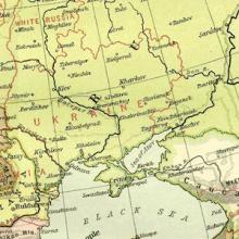
Long Teaching Module: Border Changes of the Soviet Union
Border changes have been a central part of 20th century European history. This lesson will examine a few key maps and documents that explore the creation, expansion, and dissolution of the Soviet Union.

History of NATO Expansion Map
This map shows the expansion of NATO over time. Have students identify the most recently states to join NATO. Which states have joined NATO after the collapse of communism? Which of these newer NATO states had been Soviet satellite states as opposed to full republics of the Soviet Union?

Cold War Europe Military Alliances Map
This map illustrates which states in Europe belonged to NATO or the Warsaw Pact military alliance. The white states were neutral. This map illustrates the infamous Iron Curtain and the split between West and East. Which of these states belonged to the Warsaw Pact?