World War II Military Situation Map
Annotation
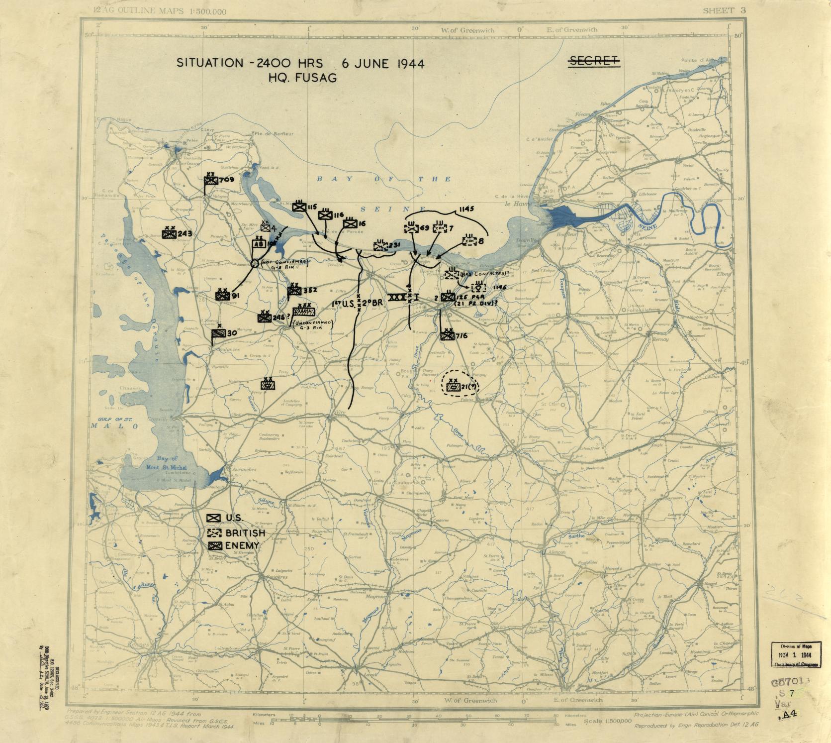
This is a map of Normandy on the day of the Normandy Landing or D-Day invasion. It comes from the larger Library of Congress collection of the Twelfth Army Group Situation Maps which together cover the period of time between June of 1944 and July of 1945. Most obviously, these maps showcase the movement and strategy of the Western Allies, specific battles, and more. Maps sometimes include some pieces of information and exclude others as a way to communicate. Sometimes, the information included on maps communicates uncertainty which in this case, was extremely important. The annotations “Not Confirmed” or “Unconfirmed” are used frequently and illustrate that the American military was operating at least partially blind, fairly frequently. These notes specifically meant that there was uncertainty about a specific unit’s location. A ? symbol was applied to the map when there was a known unit, but the map maker was unsure if they were American, British, or “enemy”. Whether it be difficulty retrieving information or misinformation being spread, there were holes in what the U.S. Army had to work with at crucial points of WWII. This specific map from June 6, 1944, reveals that these markings were sometimes even applied to US troops. This means, not only was the Army sometimes in the dark about their enemy’s movements, but they were also occasionally unaware of their own. Analyzing the background of the map also shows what was important to the people making and using it. Terrain lines are not present, but rivers, roads, and rail lines are clearly defined. This tells us something about the mode of transportation most likely to be used. Arrows drawn on the map, showing the direction a unit was intended to move, often cross these infrastructure routes, indicating that even when soldiers would be traversing the backcountry, man-made landmarks were easier to follow than natural ones. Gridlines were also drawn onto this map to create order and standardization which improved communication. This map, or any other in this collection, can be used as a primary source for students to examine as part of a World War II lesson. Thematically, this source will invite conversation about how uncertainty and false information impacted international collaboration and the war more generally. For more information on analyzing maps, visit this page: https://worldhistorycommons.org/analyzing-maps-0
Credits
Created by Annabelle Spencer, George Mason University
Allied Forces. Army Group, 12Th. Engineer Section, and 1St. Headquarters United States Army. Army Group. June 6, HQ Twelfth Army Group situation map. [England?: Twelfth Army Group, 1944] Map. https://www.loc.gov/item/2004629028/.