John Smith's Map of Virginia 1624
Annotation
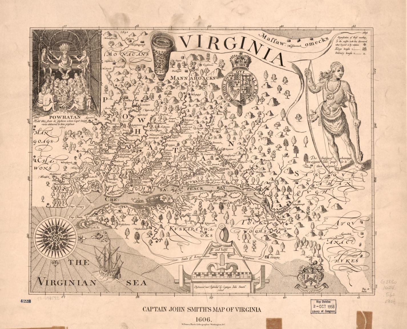
This map, created officially in 1624 is based on John Smith’s descriptions from almost 20 years prior, depicts Virginia in the early period of British North American colonialism. By thinking about the creators and their intended audience teases out additional meaning. The English public, and the Virginia Company were the primary audience who would have viewed Virginia at this point as a major opportunity for trade. Barbara Clark Smith, Curator of Social History at the Smithsonian’s National Museum of American History, interprets that these stakeholders would have looked to this map for reassurance that Virginia was flooded with riches, that they had made a “good investment.” This is likely why the Chesapeake Bay and all the rivers running off of it are so prominent and detailed on the map: Those bodies of water would have provided transportation either for trade or conquest for europeans. Clark Smith also makes note of the orientation of this map, as North appears to the right rather than the top. This orientation follows the path of the illustrated ship sailing toward the continent and clearly frames the map as from a strictly English point of view.
The illustration of a Powhatan man on the top right corner and the group of indigenous people to the left are also politically charged. They are depicted with minimal clothing, adorning themselves with animal skins and feathers, and brandishing large weapons. Alone and combined, these elements communicate the idea that the Powhatan were “savages.” Interestingly, the creators of the map did not portray the indigenous people as poverty stricken, in fact they are decorated with necklaces and headdresses which may have been an attempt to suggest their wealth that could be exploited by the British empire. The first symbol in the legend is a cross-like notation signifying that “to the crosses hath been discovered what beyond is by relation.” This means that John Smith advanced to those points himself but not beyond, and that any information about those “beyond” lands was gathered from conversations, likely with Powhatan people about the lands they controlled and about the lands of their rivals, the Manahoacs and the Monocans. This indicates once again the broader plan of colonialism and the initial conversation or relation between the two populations. It should also be noted that the majority of locations still retain their original indigenous names on this map. This shows that the Powhatan were still living in and very much in control of the territory. Further, as Clark Smith interprets, this shows that the Powhatan are attempting to use the English as much as the English are using them. The naming element here can be compared to later maps, as these names over time tend to be erased and replaced. This map can be used in lessons that focus on a variety of topics and themes including: Colonialism, Indigenous history, Mapping, and U.S. history. For more information on analyzing maps, visit this page: https://worldhistorycommons.org/analyzing-maps-0 Read also Barbara Clark Smith’s full analysis here: https://teachinghistory.org/best-practices/examples-of-historical-thinking/25096
Credits
Created by Annabelle Spencer, George Mason University
Smith, John, and Norris Peters Co. Virginia. [London, Washington, D.C., N. Peters Photo-Lithographers 190-?, 1900] Map. https://www.loc.gov/item/73694572/.