Browse Primary Sources
Locate primary sources, including images, objects, media, and texts. Annotations by scholars contextualize sources.

Tree Rings as Climate Archive
World historians who study environmental history sometimes sometimes seek out atypical sources to conduct their research.

X-ray of a cross-section of a coral core
World historians who study environmental history sometimes sometimes seek out atypical sources to conduct their research.
The Constitution of the Iroquois Nations
This text is the first seven of 117 clauses of the Constitution of the Iroquois Nation. The Iroquois Constitution, also known as the Great Law of Peace, is a written transcription of collected oral histories and traditions that documents the formation of the Haudenosaunee (the Iroquois Confederacy).
Pedro de Cieza de Léon: Chronicles of the Incas, 1540
This text is an excerpt from Spanish conquistador Pedro de Cieza de Léon's writings on the Inca and Peru. He served as a solider during campaigns in present-day Colombia and Peru. He participated in the reconquest of Peru from Spanish rebel forces. After the reconquest, he interviewed local officials and Inca lords about Inca history and culture.

Mesoamerican Pictogram
Between 1541 and 1542 Antonio de Mendoza, viceroy of New Spain, commissioned a Mesoamerican Codex containing text and Aztec pictograms. This image is one example.
Hernán Cortés: Second Letter to Emperor Charles V, 1520
This text is an excerpt of a letter sent from Spanish conquistador Hernán Cortés to the Spanish King, Charles V, in 1520. This letter is one of several extended letters sent by Cortés to Charles V detailing the conquistador's expeditions in present-day Mexico and his campaigns against the Mexica (Aztecs).
Horace, “Cleopatra Ode”
Given Horace’s position in Emperor Augustus’ court, it is not surprising that his description of Cleopatra is wholly negative. This text relies on “sourcing” and an understanding of the author’s bias and motivation for a proper reading. He describes Cleopatra as a “deadly monster” although he does, at least, admit to her bravery in submitting to the venom of the serpent.
Antony’s Meeting with Cleopatra from “Life of Antony”
Cleopatra’s claim to the Egyptian throne very much resided in her relationship and alliance with Caesar. Upon his death in the Senate, Cleopatra had lost her guarantor. Antony’s arrival in Egypt provided a second opportunity for her to secure her throne through a powerful alliance.
Cleopatra’s Meeting with Caesar
Cassius Dio’s history of the meeting between Cleopatra and Julius Caesar uses powerful word-choice to develop a characterization of the female Egyptian ruler. After Pompey’s assassination, Cleopatra immediately develops a scheme to ally with Caesar. Dio uses words like “beauty,” “striking,” and “charming” to describe her and explains that she had the “power to subjugate” anyone.
Advice to Bride and Groom (versus 14 and 18)
Plutarch’s Advice to a Bride and Groom reveals the author’s views that submissiveness is the proper behavior for a Roman patrician’s wife, which reflects the general gender norm of ancient Roman culture. The wife ought to mimic the husband’s mood at all times: to be happy when he is happy and serious when he is serious.
Aristotle’s Metaphysics
Metaphysics, written around 350 BCE, is among Greek philosohper Aristotle's most notable works. The text includes an excerpt from part seven of the ten part work.
Seneca the Younger, Moral Letters to Lucilius
Moral Letters to Lucilias was written by the Roman philosopher Seneca the Younger around 65 CE. There are 124 letters in the collection.
Sophocles, Oedipus the King
Oedipus the King, also known as Oedipus Rex, is an ancient greek play written by the Athenian philosopher, Sophocles, around 420 BCE. The text presented is an excerpted portion from the second half of the play.
Homer’s The Iliad
Homer's The Iliad is an ancient greek poem written around the eighth century. The poem is set during the Trojan war and highlights the conflict between King Agamemnon and the warrior Achilles. The text provided is an excerpt from book three.
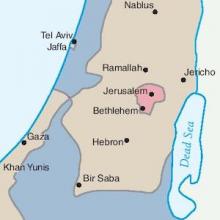
Map of the Partition of Israel and Palestine
In 1947, Britain announced that it would terminate its mandate government in Palestine. As a result, a special committee formed by the United Nations was charged with partitioning the territory into separate, sovereign states. Although the plan called for Jewish and Arab states neatly divided by plotted lines, the reality, as these maps show, was much more contested.

Map of the Union Pacific Railway
This 19th century map illustrating the many places one could travel on the Union Pacific Railway is the product of a multitude of choices made by the mapmaker. As a product for, and advertisement of, the Union Pacific Railroad, it obviously only depicts that one railway to the neglect of all of the others that were beginning to be built in the late 19th century.

The Gall-Peters Projection
Unsatisfied by the distorted view of the world that dominated the Western mind in the form of the Mercator Projection, James Gall and, later, Arno Peters engineered a new map in the 19th and 20th centuries. Based on a mathematical formula that Gall first proposed in the 19th century, Peters projected an image of the world that attempted to capture the size of objects relative to each other.

The Mercator Projection
Although the Flemish geographer and cartographer Gerardus Mercator's rendering of the earth has been criticized for the way it distorts reality, it was revolutionary in the way it organized space and distance.
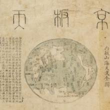
The Jingban tianwen quantu Map of the World
Like many maps in the pre-modern and early-modern world, this map from China at the end of the 18th century reflected a deeply egocentric worldview.
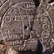
Babylonian Map Tablet
This ancient map depicts the known world as imagined by the Babylonians of the 6th century BCE. Like many ancient maps, this cuneiform tablet is concerned less with mathematically plotting space and direction than with simply capturing the various places and peoples in the world around Babylon.