Browse Primary Sources
Locate primary sources, including images, objects, media, and texts. Annotations by scholars contextualize sources.
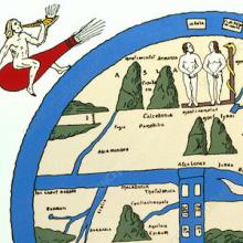
The Turin Beatus Map of the World
Before the modern age, maps offered more than just an objective, geographical survey. Often, as is the case with this world map from the 12th century, they also conveyed a set of stories that shaped the worldview of its viewers. This map, for instance, sought to convey allegorical, religious, and geographic information all at once.
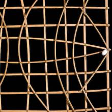
Marshall Islands Stick Charts
The Marshall Island stick charts represent a unique and non-Western tradition of mapmaking. Whereas Western maps generally attempt to capture and visualize distance and space, the charts of the Marshallese dwelt not just on general direction, with shells representing nearby islands, but, more importantly, ocean currents and swell movements.
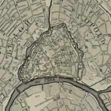
Plan for the City of Moscow
This 1793 map of Moscow shows a relatively modest and compact city when compared to the sprawling metropolis of the 21st century. From this perspective, the viewer can see the remains of a fortification wall that once encompassed the entirety of the city.
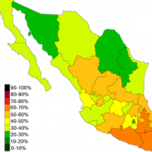
Map of Poverty in Mexico
Maps are often designed to visualize more than just space and distance. This map, for instance, visualizes how poverty is distributed throughout the various Mexican states in hopes of identifying those areas most in need. The form of this map, or the artistic way in which the map is drawn, is meant to tell the story of how deeply the issue of poverty affects the people in each region.
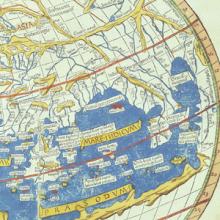
Ptolemy's World Map
Ptolemy was an ancient geographer working in Rome in the 2nd century AD.
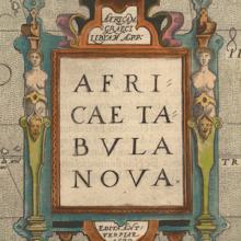
Africae tabula noua
This standard map of Africa came from a popular Atlas in the late sixteenth century. In a dramatic age of exploration, new information poured in from around the world through books and travel accounts that artists and geographers, like Abraham Ortelius, used to craft beautifully detailed maps of far off lands.
Excerpt from Aguinaldo’s Case Against The United States
The Philippines, an archipelago of over 7,000 islands in the western Pacific Ocean, had been a Spanish colony for over 300 years by the 1890s. Filipino nationalists led by Emilio Aguinaldo rebelled against Spanish rule beginning in 1896. When the United States declared war against Spain over events in Cuba in 1898, the U.S. Navy moved against Spanish colonies in the Pacific as well. U.S.
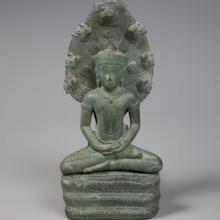
Buddha Sheltered by a Naga
This small bronze statue made in Cambodia in the twelfth century shows the serpent king Muchilinda, a type of mythical half human and half cobra being known as a naga, protecting the Buddha. Images of this scene became popular in the twelfth century Khmer Kingdom of today’s Cambodia, sponsored by King Jayavarman VII (c. 1122–1218), a strong supporter of Buddhism.
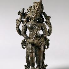
The Half-Male, Half-Female Form of Shiva (Shiva Ardhanarishvara)
This sculpture is of Shiva, originally found in Kerala, southwestern India, shows the importance of religious symbols in Hinduism. Shiva is a major Hindu god who is associated with the opposing ideas of destruction and regeneration.

Kilwa Map Illustration
This illustration shows the trading city state of Kilwa or Kilwa Kiswani on an island off the Swahili Coast in East Africa (modern Tanzania), which flourished between the 12th and 15th century.

Navigational Charts Based on Those Used by Zheng He
These two woodblock prints are part of a map printed in a seventeenth-century military treatise, and thought to be based on the maps used by Zheng He in his voyages. The map is therefore usually known as “Zheng He Map.” It depicts the coastline from China to the central eastern coast of Africa arranged as a long strip.
Excerpt from the Memoirs of Ma Huan
This excerpt is from the memoir of Ma Huan (1380-1460), a Chinese Muslim voyager and translator, who accompanied Admiral Zheng He on three of his seven voyages. The excerpt focuses on their time in Calicut (modern day Kozhikode, India) in the 1430s and highlights aspects of their experiences there.
Excerpt from Ibn Battuta's Travels in Asia and Africa 1325-1354
This source comes from the travel book of Ibn Battuta (1304-1369), a Moroccan Berber scholar and explorer.

Crucifix (Nkangi Kiditu)
This 17th-century brass Kongolese crucifix was based on European models, but transformed by the local artisan who made it. In the center is Jesus, but with large hands, flattened feet, and African facial features, including protruding eyes that convey spiritual connection. This way of representing Christ developed in Kongo during the sixteenth century, and continues to today.
Excerpt of letter from Nzinga Mbemba to Portuguese King João III
In 1526, the king of the Kongo, Nzinga Mbemba (who by this time had adopted the Christian name of Afonso I) began writing a series of twenty-four letters to the Portuguese King Joao III appealing for an end to the slave trade.
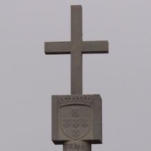
Padrão
In the 1480s, the Portuguese brought pillars (or padraos) with them in their explorations of western and southwestern Africa and placed them at prominent points, claiming these for Portugal. This is a replica of one of them, from what is now called Cape Cross, in Namibia. At the top is a cross and underneath this is the coat of arms of the kings of Portugal.
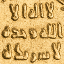
A gold dinar of Abd al-Malik minted in Damascus in 697/98
Historians use coins to find evidence of change over time. This dinar coined in 697 or 698 was minted in Damascus by the Umayyad Caliph Abd al-Malik ibn. Compared to a coin minted by the same state only a few years earlier we notice an interesting difference.
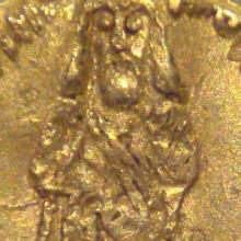
Gold dinar depicting Caliph Abd al-Malik
Coins are objects that can help historians see change over time. This Dinar coined in 695 likely depicts Abd al-Malik ibn the caliph or leader of the Umayyad Caliphate. Several aspects of the coin make it an interesting object for study.
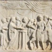
Temple of Vespasian altar
This stone alter found in Pompeii, Italy was part of temple dedicated to the Roman Emperor Vespasian who ruled from 69 to 79 CE. The alter depicts a scene of a bull being led to a religious sacrifice, a common practice in ancient Rome. Objects from the past that have been preserved can tell scholars a lot about the people who created them.
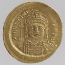
Gold Solidus of Justinian I (527–65)
Coins like this one from the Byzantine Empire can reveal a great deal. Coins found in a well can tell historians and archeologists the range of dates people settled in a given area. Coins can also help date other artifacts that researchers find near the coins. Finally coins tell historians the extent and reach of various trading networks.