Browse Primary Sources
Locate primary sources, including images, objects, media, and texts. Annotations by scholars contextualize sources.
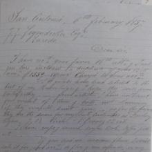
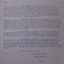
Francois Guilbeau letter on Loredo trade
This source is a favor letter, one of the most common forms of communication among merchants along the Rio Grande in the nineteenth century. This is a longer form of that type of letter, but they all share a general format that includes letting the recipient know that their payment (favor) was received, how much remained on the account, and current market conditions.
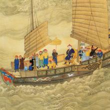
Chinese Junk, early 18th century
Junks encompass a range of different ships that were essential for maritime trade in East Asia, Southeast Asia, and the Indian Ocean for centuries. Original junks built in China were likely inspired by the design of ships visiting Chinese ports from Austronesia and Southeast Asian archipelagos.
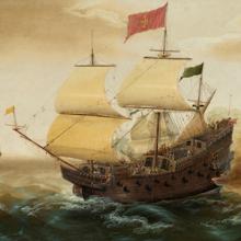
A Naval Encounter between Dutch and Spanish Warships
Spanish galleons were large ships specifically built to carry a huge amount of cargo across the vast distances of the Spanish maritime empire. The Manila Galleon Trade is a common topic in world history courses and represents the first truly global trade in world history. The manila galleons, specifically, could reach over 160ft in length.
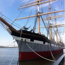
Balclutha
Balclutha was built in 1886 on the River Clyde near Glasgow, Scotland, for Robert McMillan, a Glaswegian shipbuilder who occasionally owned ships as a side-business.

HMM Algeciras
As of the beginning of 2021, the Algeciras class is the largest container vessel in the world, able to carry nearly 24,000 TEU (twenty-foot long containers). It is constructed by Daewoo Shipbuilding and Marine Engineering and owned by Hyundai Merchant Marine.
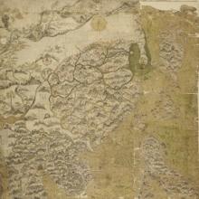
Selden Map
The Selden Map held by the Bodleian Library in Oxford, where it has been kept since 1659. This beautifully illustrated manuscript map shows East and Southeast Asia and marks maritime trading routes in the form of lines across the region. It was made in the first half of the seventeenth century somewhere in East or Southeast Asia.
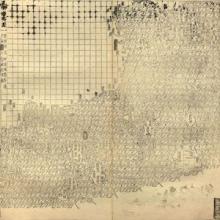
Guang yutu map
The map of the “South-Eastern ocean barbarians” from the 1558 edition of the atlas Guang yutu. This atlas is divided into two parts, the first one deals with the geography of China, the second one with the Chinese borderlands, thematic maps, and maps of non-Chinese regions. This map shows the coast of China surrounded by many islands, all shaped more or less in the same way.
Excerpts from the Treaty of Fort Stanwix (1768)
After decades of skirmishing and cold-war jostling, tensions between Great Britain and France all across the globe finally came to a head in the Seven Years’ War (1756-1763). Indians were central players in the war, however many indigenous on both sides were concerned about the futures of themselves and their lands since the war ended with French cessions of their claims in North America.
Excerpts from the Treaty of Lancaster (1744)
With the threat of war with France looming on the horizon, the English colonies treated with the Iroquois Confederacy to determine a clearer boundary line between Indian lands and the western edges of the English colonies in pursuit of peace. The Treaty of Lancaster (1744) established the line at the eastern foot of the Shenandoah Mountains.
Excerpts from the Treaty of Albany (1722)
By the mid-18th century, the Iroquois Confederacy was a significant sovereign power and the main physical buffer between the English colonies in the northeast (New York, Pennsylvania, Virginia, Maryland, and New England) and French settlements around the Great Lakes and St. Lawrence River.
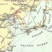
Southern Manchuria Railway (1906-1945)
The world’s earliest locomotive-operated railroads, short stretches transporting coal and ore locally from mines to factories and furnaces, were developed in Britain between 1800 and 1825. Soon the potential for transporting all kinds of goods as well as passengers became apparent, and by the 1830s railways were also being built in France, Prussia and the United States.
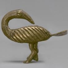
Akan Gold-Weight in the Shape of the Sankofa Bird
These intricate figurines, made by skilled West African smiths, were measuring instruments central to world flows of capital and commerce through medieval and early modern times.
Emmerton Letter, 1926
Between 1919 and 1935, citizens of the U.S. and Canada complained about industrial pollution from an American company called the Solvay Process Company (also called the Michigan Alkali Corporation), which dumped its wastes on Fighting Island, in the Detroit River. The island is in the United States, but the boundary line runs past it through the Detroit River.
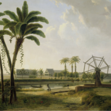
View of the Coffee Plantation Marienbosch in Surinam
This painting is a view of the Marienbosch coffee plantation along the banks of the Commewijne River in the Dutch colony of Surinam (present-day Suriname). Alongside coffee, the plantation also produced cotton and cocoa. The artist, Willem de Klerk, never visited Surinam. Instead, he based this painting on a drawing made by Alexander Ludwich Brockmann.
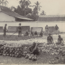
Copra Production in the Dutch East Indies
This photograph, taken by Onnes Kurkdjian, depicts men and women preparing copra in the Dutch East Indies in the early twentieth century. Copra is dried coconut kernels. Once sufficiently dried, laborers then crush the copra to expel its valuable coconut oil. The extracted oil is used for a variety of different products, such as soaps and cosmetics.
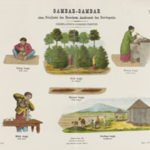
Coffee Production in the Dutch East Indies
This is a page from an educational print for children called Gambar-Gambar akan Peladjaran dan Kasoekaän Anak-anak dan Iboe-bapanja (Prints for the Benefit and Pleasure of Young and Old). The collection of prints, totaling 24 pages, depict various aspects of Indonesian life under Dutch colonial rule in the late nineteenth century.
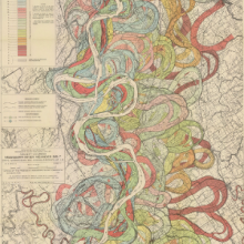
Ancient Courses: Mississippi River Meander Belt
This is one of fifteen maps of the Mississippi River created by cartographer and geologist Dr. Harold N. Fisk in 1944. The maps were part of Fisk's Geological Investigation of the Alluvial Valley of the Lower Mississippi River for the U.S. Army Corp of Engineers.
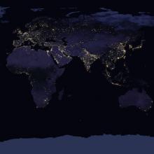
World Light Map
In "38 maps that explain the global economy", Matthew Yglesias has captured for Vox the prominent features of our contemporary global economy and society. For example, this map from NASA is a composite satellite image that shows how each region of the world appears at night.
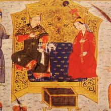
Sorghaghtani Beki and Tolui
In this illustration from Rashid al-Din’s Compendium of Chronicles Sorghaghtani Beki and Tolui sit together on a pillowed throne. Here the artist depicts different aspects of ideal Mongol masculinity than do illustrations of warriors, as Tolui interacts in a dignified way with the court ladies and officials surrounding him.

Sorghaghtani Beki in the eyes of court historians
Sorghaghtani Beki, the wife and then widow of Chinggis Khan’s youngest son Tolui, appears in many contemporary written sources about the Mongol Empire, and is always viewed positively.