Modern (1800 CE - 1950 CE)

Mexico Cartoon, 1846
This cartoon was published in New York in June 1846 as a lithograph, a month after the United States declared war on Mexico on May 13, 1846 to begin the Mexican-American War, which resulted in U.S. annexation of Mexico’s northern territory.

Tomb of General Juan Lavalle
Argentina declared independence from Spain in 1816 and eventually achieved it after several years of fighting royalist forces. Juan Lavalle was born in Buenos Aires in 1797, and remained in Argentina for most of his life.

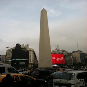
The Obelisk of Buenos Aires
Built 1936 to commemorate the anniversary of the founding of the city, the Obelisk stands in downtown Buenos Aires, Argentina. It stands 67.5 meters tall, made of concrete and stone. The nation of Argentina celebrates its independence day on July 9th.

Ottoman Reform Decree, 1856
The Imperial Reform Edict of Ottoman Sultan Abdulmejid I, appearing originally in 1856 and subsequently in this 1874 publication, promised equality of access to education, government appointments, military service, and administration of justice to all, regardless of religion, language, or race.
Poem by Qiu Jin, Chinese feminist
While the discussion surrounding the Chinese practice of footbinding often focuses on the writings of western missionaries, the example of Qiu Jin, a Chinese feminist and poet, demonstrates that the practice was criticized by Chinese individuals as well.

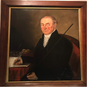
Portrait of Manuel Mansilla
This painting depicts Manuel Mansilla, the Alguacil Mayor (sheriff) of the city of Buenos Aires. He held this position from 1795-1821, during a key transitional moment. When he began his tenure, the city belonged to the Viceroyalty of the Rio de la Plata, under Spanish rule.

Mausoleum of José de San Martín
In 1816, after more than two centuries of Spanish rule, the nation of Argentina declared its independence. One of the leaders of the independence movement was José Francisco de San Martín y Matorras, more commonly known as General San Martín. He fought in battles in Argentina, Peru, and Chile.

Legislative Palace of Uruguay
The Legislative Palace of Montevideo, Uruguay, was built in the early twentieth century. Construction lasted from 1904 to 1925 under the supervision of Vittorio Meano and Gaetano Moretti. It is located in the Aguada barrio, or neighborhood, of the city.

Ottoman Decree Regarding Protestants, 1850
This imperial decree, or firman, was translated from Ottoman Turkish to English by the American Board of Commissioners for Foreign Missions.

Cartoon about the Ottoman Empire
This cartoon appeared in the popular British magazine Punch on September 15, 1853. In it, France is personified based on the mustachioed Emperor Napoleon III, and Britain appears as the symbolic figure John Bull.