Geography

Revolutionary France 1799
Map of Europe in 1799 depicting Revolutionary France, territories occupied by French forces, and Sister Republics.
This source is a part of the The Napoleonic Experience teaching module.

Ethnic Groups in Yugoslavia
In 1990, the Yugoslav Communist Party divided into several separate parties, one for each of the six Yugoslav Republics. Tensions among the ethnic groups of Yugoslavia, divided among the republics, led to an outbreak of a civil war by 1991.

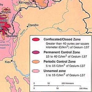
Radiation Contamination after the Chernobyl Disaster
On April 26, 1986, an explosion at the Chernobyl Nuclear Power Plant in Ukraine led to the radioactive contamination of the surrounding countryside and to radioactive fallout throughout Eastern and Western Europe.

Soviet Map, 1982
This map provides one representation of the national composition of the Soviet Union in the early 1980s. As the distribution of colors indicates, each of the major ethnic groups occupied specific regions of the country.

Soviet Nationalities Map, 1989
This map offers a different representation of the same information as in Document 1. In this case, the population distribution of each Soviet republic is depicted in the pie charts and in the accompanying table.

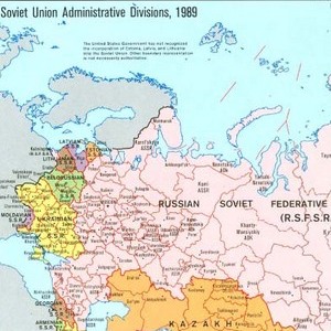
Soviet Administrative Map, 1989
This map describes the administrative structure of the Soviet Union. The fifteen Soviet federative socialist republic provided one division along national lines, yet this map also demonstrates how each region was further divided into territorial units.

Map of Distribution of Languages of Austria-Hungary after World War I
The original map came from the Perry-Castañeda Library Map Collection at the University of Texas at Austin. Timişoara (Temesvar in Hungarian) in Western Romania was long under Habsburg rule. Like much of Austria-Hungary, the city has been ethnically and religiously diverse.

Eastern and Central Europe After 1989
The nations formed following the break up of the Soviet Union. The Soviet Union is no longer on this map. It has been replaced by several new independent states—Moldova and Ukraine among them. The former Yugoslavia has also fragmented into several states.

Eastern and Central Europe After 1989
The nations formed following the break up of the Soviet Union. The Soviet Union is no longer on this map. It has been replaced by several new independent states—Moldova and Ukraine among them. The former Yugoslavia has also fragmented into several states.

The Regions of Contemporary Romania within its post-World War II Borders
The Map showing the political and administrative areas of Romania. While the borders have remained stable since 1945, some of the neighboring states have changed after the fall of communism in the area.