North/Central America

Foundations: Research and Sponsorship
The Brazilian intellectual Paulo Duarte wrote Tracy Kittredge of the Social Science Division of the Rockefeller Foundation in 1941.
Native Languages of the Americas
Native Languages of the Americas is a potent and valuable resource for introducing historical and contemporary linguistics into the classroom as an extension of the discussion of native peoples in the Western Hemisphere.Source Collection: Analyzing Treaties between the Iroquois Confederacy and the English Colonies in the 18th Century
During the 18th century, interactions between native peoples and Europeans were a regular occurrence not just along the colonial frontiers, but in French, English, and Spanish cities across the continent.

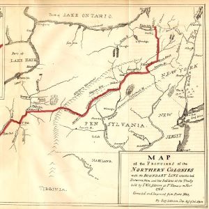
Map of the Treaty of Fort Stanwix, 1768
In 1768, Sir William Johnson received permission from the British Crown to hold a treaty council with the Iroquois Confederacy and its dependents in order to establish a more official and lasting boundary line without French pressures.
Excerpts from the Treaty of Logg's Town (1752)
As French and British powers jostled for dominance in the Ohio Country, both courted the Six Nations and their allies. The Six Nations held sway and power over mass amounts of territory—territory that French and British interests wished to control.

Short Teaching Module: Connecting Local and Global History via Mercantile Networks
European merchants spread throughout the world seeking new markets. In doing so, they actively connected remote localities to global networks across multiple continents.

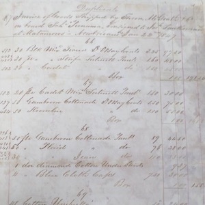
Invoice of goods shipped from New Orleans to Matamoros, Mexico in 1847
This image is of an invoice of items shipped from an English firm in New Orleans, Thorn & McGrath, to José San Román in Matamoros, Mexico. It consists primarily of men’s clothing. Studying this invoice gives us a significant insight into how European networks drew the local into the global.

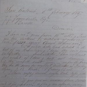
Francois Guilbeau letter on Loredo trade
This source is a favor letter, one of the most common forms of communication among merchants along the Rio Grande in the nineteenth century.
Excerpts from the Treaty of Fort Stanwix (1768)
After decades of skirmishing and cold-war jostling, tensions between Great Britain and France all across the globe finally came to a head in the Seven Years’ War (1756-1763).
Excerpts from the Treaty of Lancaster (1744)
With the threat of war with France looming on the horizon, the English colonies treated with the Iroquois Confederacy to determine a clearer boundary line between Indian lands and the western edges of the English colonies in pursuit of peace.