Europe
Excerpt from letter by Lady Mary Wortley
Travel writing by women can reveal a number of themes in world history. One useful example are the letters written by Lady Mary Wortley Montagu (1689-1786) who worked as a missionary in Turkey.
Excerpt from Travels in Africa
Imperialism is one of the most pertinent topics in relation to travel and exploration. By the end of the 19th century, the spread of European imperialism had made many areas of the world “safe” for women travelers.
Short Teaching Module: European Maps of the Early Modern World
I use images of three historical maps for topics on colonial exploration and for interpreting historical evidence in undergraduate courses on history and historical methodology. I have several aims in using the maps.

From John Bartholomew, Literary and historical atlas of America
This unusual map appeared in a 1911 atlas of America by John George Bartholomew, a prestigious Scottish cartographer and geographer. In this map Bartholomew dramatized the provincialism of European cartography three centuries earlier.
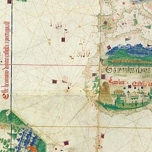
Cantino planisphere
The famous Cantino planisphere was made in 1502 by an anonymous Portuguese official at the request of Alberto Cantino, an Italian agent in Lisbon of Ercole d’Este, Duke of Ferrara.

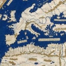
World map by Henricus Martellus
Henricus Martellus was a German geographer and cartographer who worked in the Italian city of Florence from 1480 to 1496. His book of 1490, Insularium Illustratum ("Illustrated Book of Islands"), in which this map appeared, was widely circulated for two reasons.
, Safavid Iran, late 16th century, 2.31m X 1.65m, media - silk, wool, knotted pile, <a href=\"https://collections.vam.ac.uk/item/O54294/the-salting-carpet-carpet-unknown/\">Victoria & Albert Museum</a>")
Short Teaching Module: Early Modern Islamic Carpets as Transcultural Objects
Islamic carpets were ubiquitous in the early modern period (1500-1800) in Europe as much as it was in the Islamic world. They were important objects of decor within homes, imperial palaces, and religious buildings.
, Safavid Iran, late 16th century, 2.31m X 1.65m, media - silk, wool, knotted pile, Victoria & Albert Museum")
Islamic Carpets
These three carpets made in the period between the 16th and 18th centuries show two distinct types of carpets produced in the Islamic World for particular culture-specific uses.
LSE Digital Library
The LSE Digital Library is an important and valuable archive chronicling not just the history of a storied institution but also British and global history more broadly.