Browse Primary Sources
Locate primary sources, including images, objects, media, and texts. Annotations by scholars contextualize sources.

Lisbon Port Entry List for Colonial American Ships, 1771
This is just one example of thousands of pages and documents that the Portuguese use to manage and record the trade coming in and out of their ports. The one chosen here is particularly interesting as the 7th entry (2nd from bottom) shows that an English ship has arrived and paid duties for its cargo.
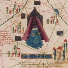
Catalan Map of the World, c.1450
Dated to the mid-fifteenth century, this Catalan world map is over a meter in diameter on a sheet of vellum (high-quality parchment made of calfskin). Unlike many other surviving charts, this was not meant for practical navigation, though it was based on such nautical charts.
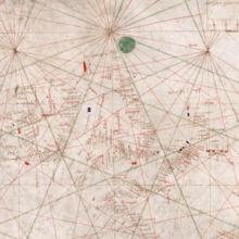
Nautical Chart, 1385
This nautical chart is signed by Majorcan cartographer Guglielmo Soler and dated to 1385, and ranges from the Black Sea to the Atlantic. Less beautiful than the Catalan map, it was also more practical for navigators to use.
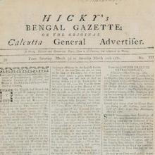
Hicky's Bengal Gazette
Hicky’s Bengal Gazette was the first printed newspaper to be published in India. While the cartoon of Henry Dundas alluded to governmental control over the flow of information between Britain and Bengal, newspapers such as Hicky’s Bengal Gazette served as an alternative and public venue for the circulation of information and even the expression of anti-government views.
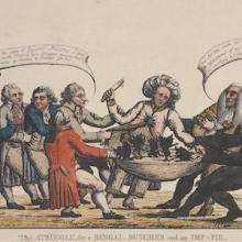
Cartoon Depicts Debate at Hasting's Impeachment Trial, 1788
Printed in London in 1788, this satirical print was a response to the debate unleashed by the impeachment trial of Warren Hastings, the former and first Governor General of India, as well as the impeachment proceedings initiated against Elijah Impey, the former and first Chief Justice of the Supreme Court of Judicature in Calcutta, Bengal.
Cartoon Mocking British Policy toward India, 1788
This satirical print from 1788 constituted a cartoonist’s effort to make sense of and criticize growing governmental control over territories in South Asia. “Dun Shaw” or Henry Dundas, the British minister and leading member of the Board of Control for India Affairs is shown extending his leviathan-like self across Britain and Bengal.
Chilean Consul Writes of Immigrants Seeking to Avoid Military Service, 1865
This document is a portion of a letter, written by José de la Cruz Zenteno, the Chilean consul in Mendoza, Argentina to the Minister of Foreign Relations in Chile is from the National Archive of Chile. Mendoza was and is an Argentinian province that borders Chile.

Chilean Consul Writes of Immigrants Needing Assistance, 1864
Found in the National Archive of Chile, this is a letter from José de la Cruz Zenteno, the Chilean consul in Mendoza, Argentina to the Minister of Foreign Relations in Chile. Mendoza was and is a province that borders Chile.
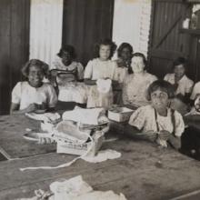
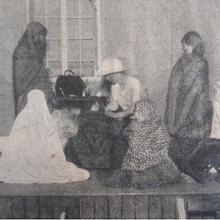
Sewing Classes at Mount Margaret Mission
These two photographs, from the State Library of Western Australia, show Aboriginal girls learning to sew from Dorothy Lovick at the Mount Margaret Mission in Laverton, Australia, in the 1930s. The first photograph shows a middle school class, while the second one features a senior class.
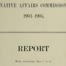
South African Native Affairs Commission report on education
In 1903, Alfred Milner, the British High Commissioner for South Africa, appointed the South African Native Affairs Commission to examine “the status and condition of the Natives” and to provide recommendations “on questions concerning Native policy” (1-2). When the Commission published its report in 1905, education formed a central theme.
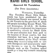
“Maori Girls School”
This article, which was published in the newspaper Manawatu Times on April 14, 1905, announces the opening of a school for Māori girls. As described in the article, while missionaries and the colonial state originally focused on educating youth, by which it meant only boys, they gradually realized the necessity of girls’ education.
Video: Boy Scouts at 1929 World Jamboree Perform as Native Americans
This video features film footage of events at the Boy Scouts’ third World Jamboree, held in England in 1929. The jamboree was known as the “Coming of Age” Jamboree, since it marked twenty-one years since the foundation of the Boy Scouts.
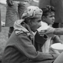
Video: Indian Boy Scouts at 1929 World Jamboree
This video features film footage of events at the Boy Scouts’ third World Jamboree, held in England in 1929. The jamboree was known as the “Coming of Age” Jamboree, since it marked twenty-one years since the foundation of the Boy Scouts. The footage reveals the importance of militarism and representations of masculinity to the Boy Scout movement.
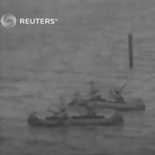
Video: March of Flags from 1929 Boy Scout World Jamboree
This video shows the opening ceremony at the Boy Scouts’ third World Jamboree, held in England in 1929. The jamboree was known as the “Coming of Age” Jamboree, since it marked twenty-one years since the foundation of the Boy Scouts. In the video, Scouts are marching with the flags of their respective countries.
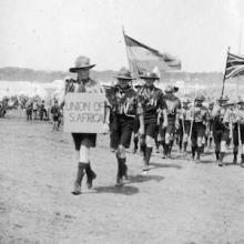
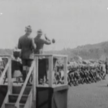
Photograph of the Boy Scout World Jamboree in 1929
This photograph shows the South African contingent at the Boy Scouts’ third World Jamboree, held in England in 1929. The jamboree was known as the “Coming of Age” Jamboree, since it marked twenty-one years since the foundation of the Boy Scouts.
Photograph of “Indian Tableaux at Endon”
This photograph, which was originally published in the G.F.S. Magazine in September 1923, is from a tableau performed by members of the Girls’ Friendly Society (GFS), which was a youth organization akin to the more popular Girl Guides.
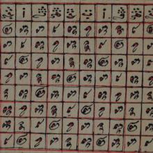
Calendar from Cham manuscript, early 20th century
An image of the Cham calendar from an early 20th century Cham manuscript. The column on the left and top row indicate measurements of months of the calendar drawn from the Islamic lunar calendar. Numerals written in Cham script in the middle are symbolic of the Cham Hindu solar calendar.
Ariya Cam Bini
Ariya Cam Bini is one of the few ariya that has little to no historical references in the poem. It is possible to deduce from the language of the poem and from the study of extant versions of the manuscript that its origins likely lie in the 19th century. The story, however, is one of star-crossed lovers, one Cham, and one Bani.
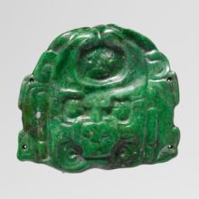
Maya Deity-Face Jade Pendant, 7th-8th century
This small carved jade ornament, about 2 inches square, was most likely the central ornament on the paper headband of a Maya ruler. Kings received the paper headband during the ritual in which they became king, signifying the moment in which they were “wrapped” into the office of kingship, transitioning from human mortal into divine king.
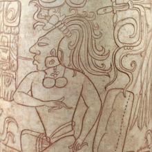
Maya Drinking Vessel with Seated Lord, 7th-8th century
This large ceramic vessel, made for drinking chocolate, shows a figure wearing a loincloth, necklace, and a large headdress that looks like the tail feathers of the quetzal bird.