Browse
Culture

Review
World History Encyclopedia
Overall this site is a fantastic resource in terms of the vast amounts of material collected for use. The site is primarily user-generated, with a system to ensure the entries uphold the website's management team's standards.Review
Africa Past & Present Podcast
The podcast could serve as a useful tool for Africa experts to stay up-to-date on scholarship, for professors in other areas to broaden their knowledge of Africa and establish relevant connections, and for students to engage in analysis of “texts” beyond the written word.
Review
National Museum of China
In summation, the NMC site has a number of areas that will prove interesting to educators and most casual visitors, but overall, its main function is to provide information about the museum itself.
Review
Livingstone Online
While the site is primarily dedicated to digitising the famed British explorer’s works, Livingstone Online is far more than a mere repository of primary sources.
Review
Teaching East Asia Online Curriculum Projects
The lessons provided are insightful explorations of Japanese history that strike a balance between academic rigour, accessibility, and being able to draw student attention, making them a valuable addition to any world history teacher’s toolkit.
Review
A History of the World in 100 Objects
Overall A History of the World in 100 Objects is a great resource to teach world history through visual culture in an accessible and succinct format for both school and college-level classes.
Review
Tasveer Ghar (A House of Pictures)
This database would be most useful for instructors teaching modern South Asia and for students in college-level seminars.
Review
Mediateca INAH
Mediateca INAH facilitates virtual engagements with over half a million interrelated digital reproductions of maps, paintings, sculptures, photographs, audio recordings, documentaries, books, as well as other textual primary sources.
Review
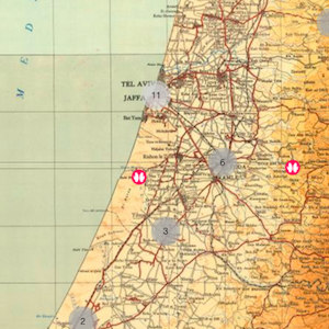
Palestinian Oral History Map
Drawing from thousands of hours of interviews from the Palestinian Oral History Archive (POHA), the map provides a stunning visual representation of Palestine in the 1940s, bringing interviewees’ memories of their lost homeland to life.
Source
The Turin Beatus Map of the World
Before the modern age, maps offered more than just an objective, geographical survey. Often, as is the case with this world map from the 12th century, they also conveyed a set of stories that shaped the worldview of its viewers.