Hakluyt's The Principall Investigations
Annotation
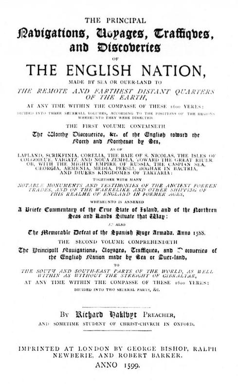
This is an image of the first page of The Principall Investigations by Richard Hakluyt. The book was originally published in 1589. This is a reprint from between 1885 and 1890. Hakluyt was born around 1552. Hakluyt developed an early interest in travel through interactions with older relatives. He studied at the Christ College of Oxford and gained a B.A. and M.A. in Geography. He could also read several languages and studied theology. Hakluyt was a preeminent collector and editor of documents relating to travel and building of the English Empire. The Principall Navigations, his most popular work, is a prominent example of his skills as an editor and a collector. The work which builds off previously published works and other travel narratives and explores the first decades of English trade and exploration. It stands out as a relatively untouched collection of primary source documents on English mercantilism and colonial expansionism. How might this work promote colonialism? It is important to really consider the source material when answering this question. Hakluyt compiled together documents were from early agents of colonization’s that had a role in expanding the British empire. As an editor or compiler of book, Hakluyt also took on a role as a promoter of colonization because he chose what was in the book and its order as well as how he would edit it to document this history. The contributors of the book created their narratives and meta narratives with their own bias. Their narratives which could simple be their perceptions of who and what they saw could have later acted as arguments for colonization. This work offers a window into the thoughts the creators and the people who they influenced with their writing. Often a way to preserve materials is to make multiple copies. This work which has been republished multiple times has preserve sources that might have otherwise been lost.
This source is a part of the Analyzing Travel Records methods module.
Transcription
THE PRINCIPAL
NAVIGATIONS, VOYAGES, TRAFFIQUES, AND DISCOVERIES
OF
THE ENGLISH NATION,
MADE BY SEA OR OUER-LAND TO
THE REMOTE AND FARTHEST DISTANT QUARTERS OF THE EARTH,
AT ANY TIME WITHIN THE COMPASSE OF THESE 1600 YERES:
DIUIDED INTO THREE SEUERALL VOLUMES, ACCORDING TO THE POSITIONS OF THE
REGIONS WHEREUNTO THEY WERE DIRECTED.
THE FIRST VOLUME CONTAINETH
The Worthy Discoveries, &c. of the English toward the North and Northeast
by Sea,
AS OF
LAPLAND, SCRIKFINIA, CORELIA, THE BAIE OF S. NICOLAS, THE ISLES OF
COLGOEVE, VAIGATZ, AND NOUA ZEMBLE, TOWARD THE GREAT RIUER OB, THE MIGHTY
EMPIRE OF RUSSIA, THE CASPIAN SEA, GEORGIA, ARMENIA, MEDIA, PERSIA, BOGHAR
IN BACTRIA, AND DIUERS KINGDOMES OF TARTARIA:
TOGETHER WITH MANY
NOTABLE MONUMENTS AND TESTIMONIES OF THE ANCIENT FORREN TRADES, AND OF THE
WARRELIKE AND OTHER SHIPPING OF THIS REALME OF ENGLAND IN FORMER AGES,
WHEREUNTO IS ANNEXED
A Briefe Commentary of the True State of Island and of the Northern Seas
and Lands Situate that Way:
AS ALSO
The Memorable Defeat of the Spanish Huge Armada, Anno 1588.
THE SECOND VOLUME COMPREHENDETH
The Principall Nauigations, Voyages, Traffiques, and Discoueries of the
English Nation made by Sea or Ouer-land,
TO
THE SOUTH AND SOUTH-EAST PARTS OF THE WORLD, AS WELL WITHIN AS WITHOUT THE
STREIGHT OF GIBRALTAR AT ANY TIME WITHIN THE COMPASSE OF THESE 1600 YERES:
DIVIDED INTO TWO SEUERAL PARTS, &c.
By Richard Hakluyt PREACHER,
AND SOMETIME STUDENT OF CHRIST-CHVRCH IN OXFORD
IMPRINTED AT LONDON BY GEORGE BISHOP, RALPH
NEWBERIE, AND ROBERT BARKER.
ANNO 1599.
Credits
From Online Books from University of Pennsylvania
http://onlinebooks.library.upenn.edu/webbin/metabook?id=hakluyt
Image and text via Internet Archive and Project Gutenberg
