Browse Primary Sources
Locate primary sources, including images, objects, media, and texts. Annotations by scholars contextualize sources.
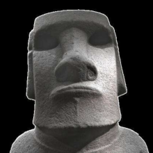
Moai on Easter Island
The Moai are large statues on Easter Island in Oceania, known for their distinctive head and facial features. The moai were created by the Rapa Nui people likely between 1250 and 1600 CE. The moai have distinctively large heads and disproportionately small bodies and are often called the “Easter Island Heads,” despite most having bodies.
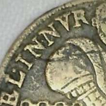
Early Modern Counter
An early modern counter of the "Reichenmaster" style, with one side showing a picture of a man using a counting board and the other side showing the alphabet. These counters were used in classrooms to teach students both to read and perform basic arithmetic.
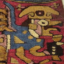
Coca Bag
This coca bag is from the Moche culture that existed in Peru between the period of 100 to 700 AD. The Moche are known for their ceramics, textiles, and metalworking practices, and this bag demonstrates the skill of Moche weavers. This coca bag dates from the 5th-7th century, and was woven from cotton and the hair of a camelid.
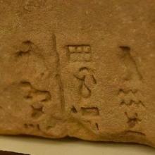
Meroitic Script
The Meroitic Script was used in the Kingdom of Kush beginning in the 3rd Century BCE, or the Meroitic Period, and had two forms, Meroitic Cursive and Meroitic hieroglyphs. There were 23 letters with four vowels in the Meroitic alphasyllabary (an alphabet where consonant/vowel units are written together).
Division with an Early Modern Counting Board
Before the rise of literacy rates, counting boards such as the one featured in the video were the most common way to perform arithmetic. After pen-and-paper arithmetic replaced counting boards, Arabic numerals also became dominant throughout Europe.
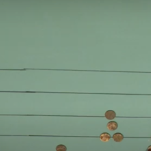
Multiplication with an Early Modern Counting Board
Before the rise of literacy rates, counting boards such as the one featured in the video were the most common way to perform arithmetic. After pen-and-paper arithmetic replaced counting boards, Arabic numerals also became dominant throughout Europe.
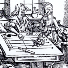
Engraving of a Rechentisch (Counting Board)
This image of an engraving depicts a man using a rechentisch, or counting board, the earliest known counting device and a precursor the abacus. The earliest known counting board is the Salamis Tablet, dating from 300 BCE, but may have been used more for gaming than for calculating. There are few surviving counting boards due to the materials used for construction and their use in daily life.
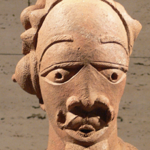
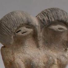
Nok Terracotta Sculptures
Nok terracotta sculptures are the earliest-known sculptures from sub-Saharan Africa, created by the Nok culture of which little is known except their ironworking and terracotta sculptures that flourished circa 1500 BCE to 1 BCE. The sculptures are figurative, with the heads or figures of humans represented, as well as animals, each unique.
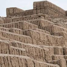
Huaca Pucllana, Ancient Pyramid in Peru
Huaca Pucllana is a pyramid site built around 500 AD by the Lima culture of Peru. The pyramid was built with seven platforms made from adobe bricks and is around 82 feet (25 meters) high, and has a plaza surrounding it. The pyramid was a site of ceremonial and religious power.
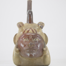
Moche Portrait Vessels
Moche portrait vessels are ceramic vessels that often featured only heads, but some also have full human bodies as well, and most are representations of adult men. The Moche existed in Peru between the period of 100 to 700 AD and are known for their ceramics, textiles, and metalworking practices, and these portrait vessels demonstrate the ceramic skill of the culture.
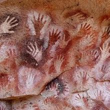
Cueva de los Manos, Rio Pinturas
Cueva de las Manos, Rio Pinturas is an archealogical site and World Heritage Site in Argentina that features cave art and rock are that dates to around 9500 to 13000 years old. The site is significant for its well-preserved depictions of art that features animals, hunting scense, and human figures, as well as outlined hands painted on the walls that the name comes from.
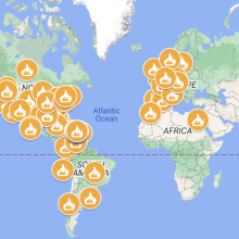
Map with Many of the Protests in Puerto Rico and the World 2019
An event in Puerto Rico that captured world attention and motivated the interest of many Puerto Ricans in the diaspora to participate was the Summer of 2019 movement. In this event, at least a third of the population of Puerto Rico took to the streets to demand political and economic change.
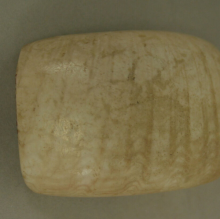
Shell Pendant or Bead from Ecuador
This pendant or bead was made from a shell and dates back to the 3rd millennium BCE. Found in Ecuador, it was likely made by the Valdivia culture, a people who lived on the western coast and mainly subsisted off fishing and farming and flourished between the years of 3500 BCE - 1500 BCE.
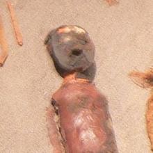
Ceramic Female Figure from Ecuador
This clay figure dates from the third millennium BCE and is evidence of the earliest known ceramic traditions of any ancient peoples in the Americas. This figure, and many others like it, are from the Valdivia culture of Ecuador. The Valdivia produced many stylized representations of human figures that often lack a clear face and were usually female.
Chinchorro Mummies
The Chinchorro mummies, named for the Chinchorro people of current-day Chile and Peru, are the world’s oldest known examples of intentional mummification. predating Egyptian examples by almost 2,000 years. Hundreds of mummies were discovered and radiocarbon dating placed their age around 7,000 years old.
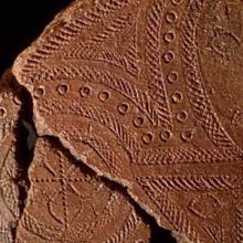
Lapita Pottery from the Santa Cruz Islands
This pottery sherd dates from around 1000 BCE and is from the Lapita culture, the likely common ancestor of contemporary Polynesian cultures. This sherd was found in the Santa Cruz Islands, part of the Solomon Islands.
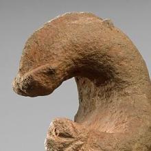
Zoomorphic Figure from Papua New Guinea
This stone figure from an unknown culture in ancient Oceania may represent an echidna, which is an egg-laying mammal that is related to the platypus. Stone figures from this region were often shaped to represent animals or human heads and could be used as mortars, pestles, club heads, or simply for rituals.
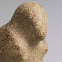
Bird Stone Figure from Papua New Guinea
This stone figure from ancient Oceania loosely shaped like a bird comes from an unknown ancient culture that lived in the highlands of Papua New Guinea.
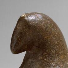
Pestle Finial from Papua New Guinea
This image is of a pestle finial in the shape of a bird from an unknown culture in ancient Oceania. Pestles are a tool used for crushing or grinding, often used for cooking ingredients such as spices, and were likely also used with other stone mortars that have been found in the region.
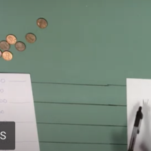
Adding and Subtracting with an Early Modern Counting Board
Before the rise of literacy rates, counting boards such as the one featured in the video were the most common way to perform arithmetic. After pen-and-paper arithmetic replaced counting boards, Arabic numerals also became dominant throughout Europe.